
How to get from Libertas (Orange Free State) to Mabopane (Gauteng)
Calculate route from Libertas (Orange Free State, South Africa) to Mabopane (Gauteng, South Africa).
The flight distance (as the crow flies) between Libertas and Mabopane is 300.1 km.
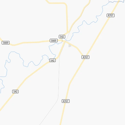
Roadmap (route) to go from Libertas to Mabopane detailed above, you can also see the course layout on the map.
While doing trip Libertas - Mabopane by car, the calculated route ends at a distance , or more straight.
Distance and duration of the route between Libertas and Mabopane
Calculation of distance and route from Mabopane to Libertas :
300.1347.0 km5h41mn
Continue onto S42 0h1mn 290 mTurn right 0h2mn 1.9 kmTurn sharp left onto R707 1h12mn 72.1 kmTurn left onto R57, R707 1h41mn 45.1 kmContinue 0h4mn 3.2 kmTurn right onto R57 1h46mn 50.4 kmTurn right onto R82 0h10mn 13.0 kmKeep left 0h0mn 201 mTurn slight left 0h2mn 2.3 kmKeep left toward R59 0h30mn 53.3 kmKeep left toward R554 0h0mn 560 mTurn right onto Swartkoppies Road 0h3mn 3.7 kmKeep left 0h1mn 708 mAt roundabout, take exit 1 onto Voortrekker Road 0h0mn 282 mTurn left onto Voortrekker Road 0h1mn 416 mAt roundabout, take exit 1 onto Voortrekker Road 0h1mn 887 mTurn left toward N12 0h14mn 25.0 kmKeep left and take N1, M1 toward Pretoria, Polokwane, Johannesburg 0h0mn 410 mKeep right and take N1 toward Pretoria, Polokwane 0h21mn 34.0 kmKeep left 0h1mn 1.4 kmKeep left 0h1mn 810 mTurn left onto Visagie Street 0h1mn 650 mContinue onto Es'kia Mphahlele Drive 0h5mn 5.0 kmKeep left and take R80 toward Soshanguve 0h19mn 28.0 kmTurn right onto Buitekant Road 0h2mn 1.8 kmTurn right 0h3mn 1.3 kmTurn right 0h0mn 52 mTurn sharp left 0h0mn 132 mArrive at destination 0h0mn 0 m
Travel from Libertas (Gauteng) to a selection of major cities.
Distances from Libertas to biggest cities in Orange Free State
Other major cities in country :
- Centurion [06], 233,386 inhabitants. 262 km
- Uitenhage [05], 228,912 inhabitants. 660 km
- Roodepoort [06], 225,000 inhabitants. 225 km
- Paarl [11], 190,000 inhabitants. 1,039 km
- Springs [06], 186,394 inhabitants. 225 km
- Carletonville [06], 182,304 inhabitants. 205 km
- Klerksdorp [10], 178,921 inhabitants. 181 km
- Midrand [06], 173,009 inhabitants. 247 km
- Westonaria [06], 156,831 inhabitants. 207 km
- Middelburg [07], 154,706 inhabitants. 318 km
- Vryheid [02], 150,012 inhabitants. 304 km
- Orkney [10], 145,801 inhabitants. 169 km
- Kimberley [08], 142,089 inhabitants. 297 km
- eMbalenhle [07], 141,741 inhabitants. 226 km
- Nigel [06], 140,644 inhabitants. 208 km
- Mpumalanga [02], 140,121 inhabitants. 336 km
- Bhisho [05], 137,287 inhabitants. 521 km
- Randfontein [06], 133,654 inhabitants. 222 km
- Worcester [11], 127,597 inhabitants. 998 km
- Rustenburg [10], 124,064 inhabitants. 284 km
Route from Mabopane to major cities (South Africa).
- Distance Mabopane Cape Town1,324 km
- Distance Mabopane Durban565 km
- Distance Mabopane Port Elizabeth972 km
- Distance Mabopane Pietermaritzburg511 km
- Distance Mabopane East London837 km
- Distance Mabopane Bloemfontein444 km
- Distance Mabopane Welkom308 km
- Distance Mabopane Newcastle311 km
- Distance Mabopane Botshabelo441 km
- Distance Mabopane Witbank121 km
- Distance Mabopane Richards Bay535 km
- Distance Mabopane Uitenhage956 km
- Distance Mabopane Paarl1,272 km
- Distance Mabopane Klerksdorp208 km
- Distance Mabopane Middelburg140 km
- Distance Mabopane Vryheid368 km
- Distance Mabopane Orkney218 km
- Distance Mabopane Kimberley489 km
- Distance Mabopane eMbalenhle150 km
- Distance Mabopane Mpumalanga541 km
Nearest cities to Libertas :
- Johannesburg, 2,026,469 inhabitants. 222 km
- Soweto, 1,695,047 inhabitants. 213 km
- Pretoria, 1,619,438 inhabitants. 275 km
- Pietermaritzburg, 750,845 inhabitants. 305 km
- Benoni, 605,344 inhabitants. 229 km
- Tembisa, 511,655 inhabitants. 248 km
- Vereeniging, 474,681 inhabitants. 169 km
- Bloemfontein, 463,064 inhabitants. 182 km
- Boksburg, 445,168 inhabitants. 225 km
- Welkom, 431,944 inhabitants. 100 km
- Newcastle, 404,838 inhabitants. 221 km
- Krugersdorp, 378,821 inhabitants. 233 km
- Diepsloot, 350,000 inhabitants. 251 km
- Randburg, 337,053 inhabitants. 233 km
- Botshabelo, 309,714 inhabitants. 156 km
- Brakpan, 305,692 inhabitants. 225 km
- Witbank, 262,491 inhabitants. 297 km
- Vanderbijlpark, 246,754 inhabitants. 164 km
- Centurion, 233,386 inhabitants. 262 km
- Roodepoort, 225,000 inhabitants. 225 km
- Springs, 186,394 inhabitants. 225 km
- Carletonville, 182,304 inhabitants. 205 km
- Klerksdorp, 178,921 inhabitants. 181 km
- Midrand, 173,009 inhabitants. 247 km
- Westonaria, 156,831 inhabitants. 207 km
- Middelburg, 154,706 inhabitants. 318 km
- Orkney, 145,801 inhabitants. 169 km
- Kimberley, 142,089 inhabitants. 297 km
- eMbalenhle, 141,741 inhabitants. 226 km
- Nigel, 140,644 inhabitants. 208 km
- Mpumalanga, 140,121 inhabitants. 336 km
- Randfontein, 133,654 inhabitants. 222 km
- Rustenburg, 124,064 inhabitants. 284 km
- Potchefstroom, 123,669 inhabitants. 174 km
- Virginia, 122,502 inhabitants. 85 km
- Brits, 122,497 inhabitants. 283 km
- Alberton, 121,536 inhabitants. 216 km
- Kroonstad, 103,992 inhabitants. 76 km
- Bethal, 101,919 inhabitants. 257 km
- Mabopane, 97,417 inhabitants. 301 km
- Kutloanong, 95,008 inhabitants. 104 km
- Stilfontein, 93,110 inhabitants. 176 km
- Delmas, 92,046 inhabitants. 245 km
- Dundee, 84,413 inhabitants. 246 km
- Phuthaditjhaba, 84,258 inhabitants. 113 km
- Bethlehem, 83,654 inhabitants. 57 km
- Sasolburg, 77,016 inhabitants. 152 km
- Mmabatho, 76,754 inhabitants. 332 km
- Standerton, 74,021 inhabitants. 204 km
- Bothaville, 71,934 inhabitants. 140 km
Location Libertas (Orange Free State) :
| Country flag |  |
| Location | Libertas |
| State | Orange Free State |
| County | Thabo Mofutsanyana District Municipality |
| Country | South Africa |
| Country code / ISO 2 | ZA |
| Latitude | -28.1776000 |
| Longitude | 27.7303900 |
| Altitude | 0 meters |
| Time zone | Africa/Johannesburg |
Location Mabopane (Gauteng) :
| Country flag | |
| Location | Mabopane |
| State | Gauteng |
| County | City of Tshwane Metropolitan Municipality |
| Country | South Africa |
| Country code / ISO 2 | ZA |
| Latitude | -25.4976800 |
| Longitude | 28.1006500 |
| Altitude | 0 meters |
| Time zone | Africa/Johannesburg |