
How to get from Palapye (Central) to Mochudi (Kgatleng)
Calculate route from Palapye (Central, Botswana) to Mochudi (Kgatleng, Botswana).
The flight distance (as the crow flies) between Palapye and Mochudi is 230.4 km.
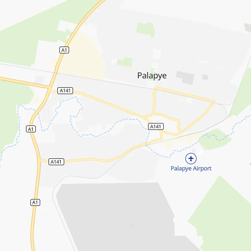
Roadmap (route) to go from Palapye to Mochudi detailed above, you can also see the course layout on the map.
While doing trip Palapye - Mochudi by car, the calculated route ends at a distance , or more straight.
Distance and duration of the route between Palapye and Mochudi
Calculation of distance and route from Mochudi to Palapye :
230.4241.4 km3h49mn
Continue 0h0mn 80 mTurn sharp left 0h1mn 428 mTurn right 0h0mn 21 mTurn left 0h0mn 243 mTurn right 0h0mn 24 mTurn left 0h0mn 45 mTurn left onto A141 0h0mn 219 mTurn right 0h0mn 117 mKeep right 0h0mn 202 mTurn right 0h0mn 113 mTurn left 0h0mn 247 mTurn right onto A141 0h5mn 4.2 kmKeep left 1h47mn 70.7 kmAt roundabout, take exit 2 onto A1 2h33mn 150.0 kmTurn left 0h0mn 55 mTurn left 0h2mn 1.0 kmTurn slight left 0h2mn 1.0 kmTurn left 0h0mn 12 mTurn right 0h3mn 1.5 kmKeep left 0h0mn 131 mKeep left 0h1mn 629 mKeep left 0h0mn 39 mKeep right 0h5mn 5.4 kmTurn right 0h1mn 1.1 kmTurn left 0h2mn 2.0 kmTurn right 0h1mn 526 mTurn left 0h0mn 42 mTurn right 0h1mn 479 mTurn left 0h0mn 23 mTurn right 0h1mn 629 mContinue 0h0mn 196 mArrive at destination 0h0mn 0 m
Travel from Palapye (Kgatleng) to a selection of major cities.
Distances from Palapye to biggest cities in Central
Other major cities in country :
Route from Mochudi to major cities (Botswana).
Nearest cities to Palapye :
- Gaborone, 208,411 inhabitants. 265 km
- Francistown, 89,979 inhabitants. 158 km
- Molepolole, 63,248 inhabitants. 266 km
- Selebi-Phikwe, 53,727 inhabitants. 97 km
- Serowe, 47,419 inhabitants. 46 km
- Kanye, 44,716 inhabitants. 326 km
- Mahalapye, 44,471 inhabitants. 70 km
- Mogoditshane, 43,394 inhabitants. 265 km
- Mochudi, 36,962 inhabitants. 231 km
- Lobatse, 30,883 inhabitants. 333 km
- Palapye, 30,650 inhabitants. 0 km
- Ramotswa, 21,450 inhabitants. 289 km
- Thamaga, 20,756 inhabitants. 286 km
- Mosopa, 19,561 inhabitants. 303 km
- Letlhakane, 18,136 inhabitants. 202 km
- Tonota, 17,759 inhabitants. 128 km
- Janeng, 16,853 inhabitants. 357 km
- Gabane, 12,884 inhabitants. 273 km
- Orapa, 9,189 inhabitants. 227 km
- Kopong, 6,895 inhabitants. 250 km
- Letlhakeng, 6,781 inhabitants. 275 km
- Otse, 6,275 inhabitants. 309 km
- Metsemotlhaba, 5,544 inhabitants. 261 km
- Rakops, 5,222 inhabitants. 332 km
- Lenchwe Le Tau, 4,992 inhabitants. 242 km
- Mmopone, 4,927 inhabitants. 259 km
- Nata, 4,794 inhabitants. 277 km
- Gweta, 4,689 inhabitants. 328 km
- Mathambgwane, 4,675 inhabitants. 174 km
- Bokaa, 4,131 inhabitants. 240 km
- Sefophe, 4,114 inhabitants. 96 km
- Ramokgonami, 3,681 inhabitants. 47 km
- Masunga, 3,639 inhabitants. 217 km
- Maunatlala, 3,361 inhabitants. 52 km
- Mopipi, 3,301 inhabitants. 277 km
- Sua, 3,141 inhabitants. 294 km
- Sebina, 3,030 inhabitants. 187 km
Location Palapye (Central) :
| Country flag |  |
| Location | Palapye |
| State | Central |
| County | |
| Country | Botswana |
| Country code / ISO 2 | BW |
| Latitude | -22.5460500 |
| Longitude | 27.1250700 |
| Altitude | 0 meters |
| Time zone | Africa/Gaborone |
Location Mochudi (Kgatleng) :
| Country flag | |
| Location | Mochudi |
| State | Kgatleng |
| County | |
| Country | Botswana |
| Country code / ISO 2 | BW |
| Latitude | -24.4166700 |
| Longitude | 26.1500000 |
| Altitude | 0 meters |
| Time zone | Africa/Gaborone |