


How to get from Piedra Negra (airport) (Maule Region) to San Vicente (O'Higgins Region)
Calculate route from Piedra Negra (airport) (Maule Region, Chile) to San Vicente (O'Higgins Region, Chile).
The flight distance (as the crow flies) between Piedra Negra (airport) and San Vicente is 212.5 km.
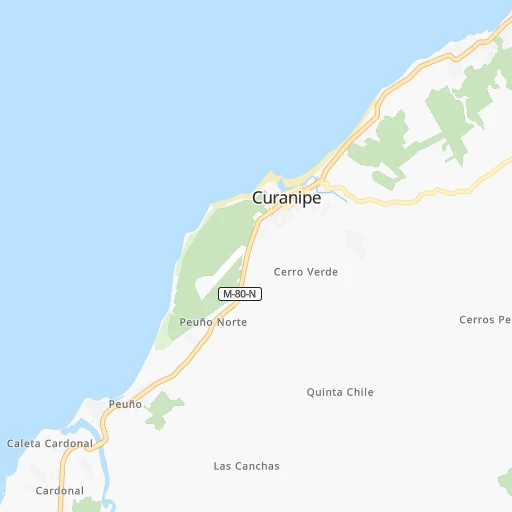
Roadmap (route) to go from Piedra Negra Airport to San Vicente detailed above, you can also see the course layout on the map.
While doing trip Piedra Negra (airport) - San Vicente by car, the calculated route ends at a distance , or more straight.
Distance and duration of the route between Piedra Negra (airport) and San Vicente
Calculation of distance and route from San Vicente to Piedra Negra (airport) :
212.5283.9 km4h37mn
Continue onto Ruta M-80-N 0h2mn 1.7 kmTurn right onto Avenida Padre Samuel Jofré 0h8mn 7.1 kmTurn left onto Profesor Luis Aparicio 0h0mn 67 mTurn right onto Arturo Prat 0h3mn 2.2 kmTurn sharp right onto Ruta M-900 0h4mn 3.5 kmTurn right onto Ruta M-50-K 0h28mn 28.8 kmKeep right onto Bombero Venegas 0h2mn 1.2 kmTurn left onto Salida Cauquenes 0h0mn 72 mKeep right and take 128 toward Parral 0h0mn 32 mTurn slight right onto Avenida Sótero del Río Gundián 0h1mn 913 mTurn left onto Maipú 0h1mn 670 mTurn sharp right onto Camino Viejo 0h1mn 604 mTurn slight right onto Ruta 128 0h8mn 7.3 kmTurn left onto Ruta Los Conquistadores 1h47mn 59.8 kmKeep right toward L-30-M 0h3mn 2.7 kmKeep right and drive toward Villa Alegre 0h0mn 393 mTurn sharp left onto Ruta L-160 0h6mn 5.1 kmTurn right onto Camino Las Rosas 0h1mn 1.2 kmKeep right and take 5 toward Talca 1h31mn 51.8 kmContinue onto Ruta 5 Sur 1h33mn 58.3 kmContinue onto Ruta 5 Sur 0h17mn 29.3 kmKeep right and take I-90-H, I-181 toward El Tambo, La Paloma 0h0mn 119 mKeep right and drive toward La Paloma 0h0mn 144 mKeep left toward I-181 0h0mn 26 mTurn left onto Camino La Paloma 0h18mn 19.2 kmTurn left onto Germán Riesco 0h1mn 849 mTurn right onto General Bernardo O'Higgins Riquelme 0h0mn 308 mTurn left onto José Miguel Carrera Verdugo 0h0mn 206 mTurn right onto Alcalde Gines Yañez Rodríguez 0h0mn 216 mTurn right onto El Limonero 0h0mn 43 mTurn left onto La Higuera 0h0mn 36 mTurn right onto Pasaje La Higuera 0h0mn 22 mArrive at destination 0h0mn 0 m
Travel from Piedra Negra (airport) (O'Higgins Region) to a selection of major cities.
Distances from Piedra Negra Airport to biggest cities in Maule Region
Other major cities in country :
- Quilpue [01], 130,263 inhabitants. 332 km
- Copiapo [05], 129,280 inhabitants. 970 km
- Los Angeles [06], 125,430 inhabitants. 182 km
- Punta Arenas [10], 117,430 inhabitants. 1,931 km
- Lo Prado [12], 104,316 inhabitants. 321 km
- Villa Alemana [01], 97,320 inhabitants. 334 km
- Coronel [06], 92,940 inhabitants. 138 km
- San Antonio [01], 85,651 inhabitants. 269 km
- Chiguayante [06], 82,545 inhabitants. 124 km
- Ovalle [07], 77,138 inhabitants. 600 km
- Quillota [01], 67,779 inhabitants. 355 km
- Penaflor [12], 65,495 inhabitants. 298 km
- Melipilla [12], 63,100 inhabitants. 274 km
- San Felipe [01], 59,294 inhabitants. 388 km
- Los Andes [01], 56,859 inhabitants. 385 km
- Buin [12], 55,441 inhabitants. 293 km
- Talagante [12], 51,764 inhabitants. 290 km
Route from San Vicente to major cities (Chile).
- Distance San Vicente Santiago116 km
- Distance San Vicente Puente Alto103 km
- Distance San Vicente Antofagasta1,202 km
- Distance San Vicente Vina del Mar163 km
- Distance San Vicente Valparaiso164 km
- Distance San Vicente Talcahuano315 km
- Distance San Vicente San Bernardo100 km
- Distance San Vicente Temuco498 km
- Distance San Vicente Iquique1,586 km
- Distance San Vicente Concepcion320 km
- Distance San Vicente La Pintana103 km
- Distance San Vicente Talca122 km
- Distance San Vicente Arica1,778 km
- Distance San Vicente Coquimbo499 km
- Distance San Vicente Puerto Montt800 km
- Distance San Vicente La Serena504 km
- Distance San Vicente Chillan259 km
- Distance San Vicente Calama1,350 km
- Distance San Vicente Osorno707 km
- Distance San Vicente Valdivia629 km
Nearest cities to Piedra Negra (airport) :
- Santiago, 4,837,295 inhabitants. 324 km
- Puente Alto, 510,417 inhabitants. 313 km
- Vina del Mar, 294,551 inhabitants. 331 km
- Valparaiso, 282,448 inhabitants. 327 km
- Talcahuano, 252,968 inhabitants. 106 km
- San Bernardo, 249,858 inhabitants. 309 km
- Temuco, 238,129 inhabitants. 321 km
- Concepcion, 215,413 inhabitants. 114 km
- Rancagua, 212,695 inhabitants. 255 km
- La Pintana, 201,178 inhabitants. 313 km
- Talca, 197,479 inhabitants. 102 km
- Chillan, 150,396 inhabitants. 97 km
- Quilpue, 130,263 inhabitants. 332 km
- Los Angeles, 125,430 inhabitants. 182 km
- Lo Prado, 104,316 inhabitants. 321 km
- Curico, 102,438 inhabitants. 160 km
- Villa Alemana, 97,320 inhabitants. 334 km
- Coronel, 92,940 inhabitants. 138 km
- San Antonio, 85,651 inhabitants. 269 km
- Chiguayante, 82,545 inhabitants. 124 km
- Linares, 69,535 inhabitants. 95 km
- Quillota, 67,779 inhabitants. 355 km
- Penaflor, 65,495 inhabitants. 298 km
- Melipilla, 63,100 inhabitants. 274 km
- Buin, 55,441 inhabitants. 293 km
- Talagante, 51,764 inhabitants. 290 km
- Lota, 49,763 inhabitants. 145 km
- Tome, 46,698 inhabitants. 89 km
- Penco, 46,091 inhabitants. 103 km
- Angol, 44,856 inhabitants. 216 km
- Rengo, 38,100 inhabitants. 229 km
- Constitucion, 37,917 inhabitants. 62 km
- Limache, 35,876 inhabitants. 340 km
- Santa Cruz, 33,283 inhabitants. 179 km
- Paine, 32,766 inhabitants. 287 km
- San Carlos, 31,517 inhabitants. 89 km
- Cauquenes, 31,362 inhabitants. 32 km
- Curanilahue, 30,611 inhabitants. 191 km
- San Vicente de Tagua Tagua, 29,560 inhabitants. 213 km
- Lampa, 29,250 inhabitants. 329 km
- Molina, 28,775 inhabitants. 149 km
- Machali, 27,595 inhabitants. 261 km
- Parral, 26,904 inhabitants. 81 km
- Arauco, 24,659 inhabitants. 166 km
- Victoria, 24,555 inhabitants. 266 km
- Graneros, 23,301 inhabitants. 265 km
- El Monte, 23,090 inhabitants. 286 km
- San Vicente, 22,572 inhabitants. 213 km
- San Javier, 22,427 inhabitants. 88 km
- Lebu, 22,345 inhabitants. 215 km
Location Piedra Negra (airport) (Maule Region) :
| Country flag |  |
| Location | Piedra Negra (airport) |
| State | Maule Region |
| County | Provincia de Cauquenes |
| Country | Chile |
| Country code / ISO 2 | CL |
| Latitude | -35.8553400 |
| Longitude | -72.6469200 |
| Altitude | 0 meters |
| Time zone | America/Santiago |
Location San Vicente (O'Higgins Region) :
| Country flag | |
| Location | San Vicente |
| State | O'Higgins Region |
| County | Provincia de Cachapoal |
| Country | Chile |
| Country code / ISO 2 | CL |
| Latitude | -34.4333300 |
| Longitude | -71.0833300 |
| Altitude | 0 meters |
| Time zone | America/Santiago |