
How to get from Blaxland Railway Station (New South Wales) to St Clair (New South Wales)
Calculate route from Blaxland Railway Station (New South Wales, Australia) to St Clair (New South Wales, Australia).
The flight distance (as the crow flies) between Blaxland Railway Station and St Clair is 17.2 km.
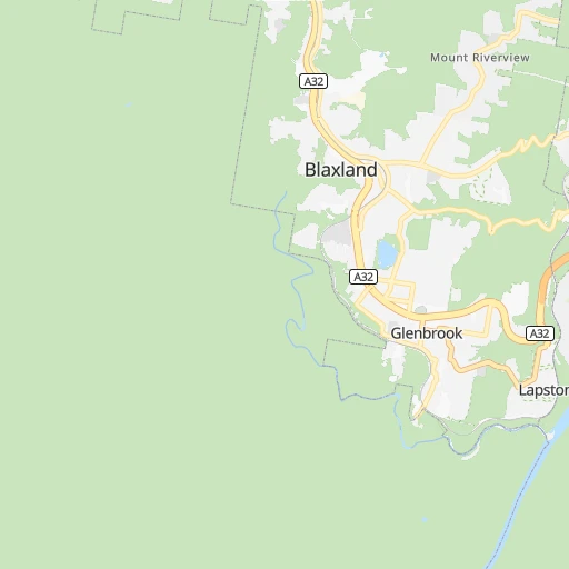
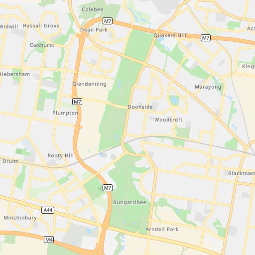
Roadmap (route) to go from Blaxland Railway Station to St Clair detailed above, you can also see the course layout on the map.
While doing trip Blaxland Railway Station - St Clair by car, the calculated route ends at a distance , or more straight.
Distance and duration of the route between Blaxland Railway Station and St Clair
Calculation of distance and route from St Clair to Blaxland Railway Station :
17.220.3 km0h19mn
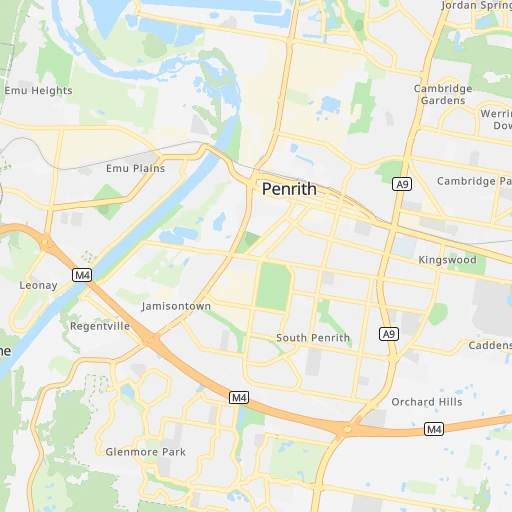
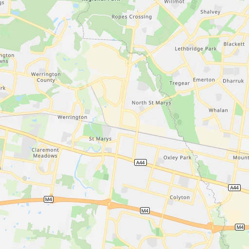
Continue 0h0mn 22 mTurn sharp right onto Wilson Way 0h1mn 575 mAt roundabout, take exit 2 onto Wilson Way 0h0mn 394 mAt roundabout, take exit 1 onto Mitchells Pass 0h1mn 502 mTurn left onto Mitchells Pass 0h4mn 2.7 kmTurn slight left onto Great Western Highway 0h1mn 958 mTurn right onto Russell Street 0h0mn 427 mKeep left onto Western Motorway Onramp and take M4 toward Penrith, Sydney 0h7mn 11.7 kmKeep left onto Mamre Road Offramp and drive toward Saint Marys, Mount Druitt, Saint Clair 0h0mn 276 mKeep right onto Mamre Road Offramp 0h0mn 127 mTurn right onto Mamre Road 0h1mn 573 mTurn left onto Banks Drive 0h0mn 323 mAt roundabout, take exit 2 onto Banks Drive 0h1mn 1.0 kmAt roundabout, take exit 1 onto Banks Drive 0h0mn 297 mAt roundabout, take exit 2 onto Banks Drive 0h0mn 259 mTurn left onto Harvey Circuit 0h0mn 168 mArrive at destination 0h0mn 0 m
Travel from Blaxland Railway Station (New South Wales) to a selection of major cities.
Distances from Blaxland Railway Station to biggest cities in New South Wales
- Kellyville,27,971 inhabitants.32 km
- Port Stephens,27,531 inhabitants.178 km
- Banora Point,27,368 inhabitants.676 km
- Maroubra,26,538 inhabitants.62 km
- Coffs Harbour,26,353 inhabitants.451 km
- Mosman,26,236 inhabitants.59 km
- Randwick,25,819 inhabitants.62 km
- Strathfield,25,813 inhabitants.46 km
- Quakers Hill,25,017 inhabitants.25 km
- Campsie,24,541 inhabitants.49 km
- Marrickville,23,161 inhabitants.53 km
- Granville,22,889 inhabitants.39 km
- Armidale,22,673 inhabitants.374 km
- Ashfield,22,000 inhabitants.50 km
- Cabramatta,21,783 inhabitants.35 km
- Greystanes,21,703 inhabitants.32 km
- Carlingford,21,364 inhabitants.41 km
- Liverpool,21,317 inhabitants.35 km
- Caringbah,21,283 inhabitants.58 km
- Goulburn,20,940 inhabitants.139 km
Other major cities in country :
- Bunbury [08], 68,248 inhabitants. 3,229 km
- Armadale [08], 62,296 inhabitants. 3,222 km
- Rockhampton [04], 61,724 inhabitants. 1,154 km
- Adelaide Hills [05], 60,394 inhabitants. 1,101 km
- South Brisbane [04], 60,000 inhabitants. 734 km
Route from St Clair to major cities (Australia).
- Distance St Clair Melbourne690 km
- Distance St Clair Brisbane737 km
- Distance St Clair Perth3,256 km
- Distance St Clair Adelaide1,126 km
- Distance St Clair Gold Coast693 km
- Distance St Clair Canberra225 km
- Distance St Clair Logan City721 km
- Distance St Clair Geelong754 km
- Distance St Clair Hobart1,055 km
- Distance St Clair Townsville1,665 km
- Distance St Clair Cairns1,944 km
- Distance St Clair Toowoomba703 km
- Distance St Clair Darwin3,119 km
- Distance St Clair Rockingham3,260 km
- Distance St Clair Launceston909 km
- Distance St Clair Bendigo677 km
- Distance St Clair Ballarat754 km
- Distance St Clair Mandurah3,255 km
- Distance St Clair Mackay1,416 km
- Distance St Clair Bundaberg1,006 km
Nearest cities to Blaxland Railway Station :
- Sydney, 4,627,345 inhabitants. 57 km
- Canberra, 367,752 inhabitants. 219 km
- Newcastle, 308,308 inhabitants. 142 km
- Wollongong, 292,190 inhabitants. 80 km
- Maitland, 67,132 inhabitants. 143 km
- Tamworth, 47,597 inhabitants. 297 km
- Port Macquarie, 41,491 inhabitants. 336 km
- Queanbeyan, 40,661 inhabitants. 219 km
- Orange, 39,329 inhabitants. 149 km
- Blacktown, 39,000 inhabitants. 29 km
- Castle Hill, 35,389 inhabitants. 36 km
- Nowra, 34,479 inhabitants. 127 km
- Baulkham Hills, 33,945 inhabitants. 35 km
- Auburn, 33,122 inhabitants. 41 km
- Bathurst, 33,110 inhabitants. 102 km
- Dubbo, 32,327 inhabitants. 251 km
- Bankstown, 30,572 inhabitants. 44 km
- Hurstville, 29,822 inhabitants. 52 km
- Kellyville, 27,971 inhabitants. 32 km
- Port Stephens, 27,531 inhabitants. 178 km
- Maroubra, 26,538 inhabitants. 62 km
- Mosman, 26,236 inhabitants. 59 km
- Randwick, 25,819 inhabitants. 62 km
- Strathfield, 25,813 inhabitants. 46 km
- Quakers Hill, 25,017 inhabitants. 25 km
- Campsie, 24,541 inhabitants. 49 km
- Marrickville, 23,161 inhabitants. 53 km
- Granville, 22,889 inhabitants. 39 km
- Ashfield, 22,000 inhabitants. 50 km
- Cabramatta, 21,783 inhabitants. 35 km
- Greystanes, 21,703 inhabitants. 32 km
- Carlingford, 21,364 inhabitants. 41 km
- Liverpool, 21,317 inhabitants. 35 km
- Caringbah, 21,283 inhabitants. 58 km
- Goulburn, 20,940 inhabitants. 139 km
- Punchbowl, 20,236 inhabitants. 46 km
- Hornsby, 19,863 inhabitants. 46 km
- St Clair, 19,837 inhabitants. 17 km
- Glenmore Park, 19,200 inhabitants. 8 km
- Epping, 18,969 inhabitants. 44 km
- Cherrybrook, 18,778 inhabitants. 40 km
- Katoomba, 18,593 inhabitants. 28 km
- Parramatta, 18,448 inhabitants. 37 km
- Fairfield, 18,081 inhabitants. 34 km
- Engadine, 17,937 inhabitants. 52 km
- Eastwood, 17,865 inhabitants. 44 km
- Forster, 17,591 inhabitants. 249 km
- Dee Why, 17,463 inhabitants. 64 km
- Wahroonga, 17,371 inhabitants. 47 km
- North Ryde, 17,208 inhabitants. 48 km
Location Blaxland Railway Station (New South Wales) :
| Country flag |  |
| Location | Blaxland Railway Station |
| State | New South Wales |
| County | Blue Mountains Municipality |
| Country | Australia |
| Country code / ISO 2 | AU |
| Latitude | -33.7437900 |
| Longitude | 150.6098600 |
| Altitude | 0 meters |
| Time zone | Australia/Sydney |
Location St Clair (New South Wales) :
| Country flag | |
| Location | St Clair |
| State | New South Wales |
| County | Penrith Municipality |
| Country | Australia |
| Country code / ISO 2 | AU |
| Latitude | -33.7972800 |
| Longitude | 150.7847000 |
| Altitude | 0 meters |
| Time zone | Australia/Sydney |


