
How to get from Aire Parque (airport) (Missouri) to Wentzville (Missouri)
Calculate route from Aire Parque (airport) (Missouri, United States) to Wentzville (Missouri, United States).
The flight distance (as the crow flies) between Aire Parque (airport) and Wentzville is 86.9 km.
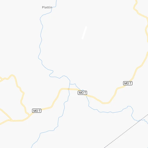
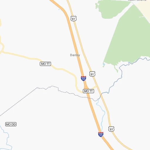
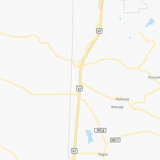
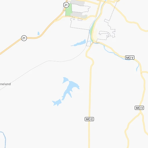
Roadmap (route) to go from Aire Parque Airport to Wentzville detailed above, you can also see the course layout on the map.
While doing trip Aire Parque (airport) - Wentzville by car, the calculated route ends at a distance , or more straight.
Distance and duration of the route between Aire Parque (airport) and Wentzville
Calculation of distance and route from Wentzville to Aire Parque (airport) :
86.9107.8 km1h30mn
Continue 0h1mn 388 mTurn right onto Plattin School Road 0h2mn 1.1 kmTurn left onto Harness Road 0h3mn 1.6 kmTurn right onto Plattin Road 0h14mn 7.2 kmTurn left onto US 61 0h1mn 1.5 kmTurn sharp left onto I 55 Business, US 67 0h0mn 113 mKeep right and take I 55 North toward Saint Louis 0h16mn 27.8 kmKeep right and take MO 141 toward Arnold 0h0mn 299 mKeep left and take MO 141 North toward Arnold 0h11mn 14.3 kmKeep right onto MO 141 0h13mn 15.4 kmKeep left and take I 64 West, US 40 West, US 61 North toward Wentzville 0h25mn 36.5 kmKeep right and drive toward Pitman Avenue 0h0mn 261 mTurn left onto Pitman Avenue 0h0mn 113 mKeep right 0h0mn 53 mTurn slight right onto Luetkenhaus Boulevard 0h0mn 188 mTurn left onto East Pearce Boulevard 0h1mn 746 mTurn left onto North Elm Street 0h0mn 66 mTurn right onto East Allen Street 0h0mn 61 mArrive at destination 0h0mn 0 m
Travel from Aire Parque (airport) (Missouri) to a selection of major cities.
Distances from Aire Parque Airport to biggest cities in Missouri
- University City,35,058 inhabitants.60 km
- Ballwin,30,577 inhabitants.55 km
- Liberty,30,450 inhabitants.372 km
- Raytown,29,401 inhabitants.368 km
- Mehlville,28,380 inhabitants.44 km
- Kirkwood,27,750 inhabitants.52 km
- Maryland Heights,27,389 inhabitants.66 km
- Gladstone,26,861 inhabitants.382 km
- Hazelwood,25,661 inhabitants.73 km
- Grandview,25,256 inhabitants.371 km
- Webster Groves,23,177 inhabitants.53 km
- Belton,23,168 inhabitants.369 km
- Sedalia,21,516 inhabitants.256 km
- Arnold,21,357 inhabitants.35 km
- Ferguson,21,059 inhabitants.70 km
- Nixa,20,984 inhabitants.283 km
- Raymore,20,374 inhabitants.362 km
- Affton,20,307 inhabitants.48 km
- Rolla,20,019 inhabitants.123 km
Other major cities in country :
- Charlotte [NC], 827,097 inhabitants. 911 km
- Seattle [WA], 684,451 inhabitants. 2,788 km
- Denver [CO], 682,545 inhabitants. 1,275 km
- El Paso [TX], 681,124 inhabitants. 1,628 km
- Detroit [MI], 677,116 inhabitants. 780 km
- Boston [MA], 667,137 inhabitants. 1,705 km
- Memphis [TN], 655,770 inhabitants. 332 km
- New South Memphis [TN], 641,608 inhabitants. 339 km
- Portland [OR], 632,309 inhabitants. 2,781 km
- Oklahoma City [OK], 631,346 inhabitants. 700 km
- Las Vegas [NV], 623,747 inhabitants. 2,200 km
- Baltimore [MD], 621,849 inhabitants. 1,203 km
- Washington, D.C. [DC], 601,723 inhabitants. 1,165 km
- Milwaukee [WI], 600,155 inhabitants. 587 km
- South Boston [MA], 571,281 inhabitants. 1,705 km
- Albuquerque [NM], 559,121 inhabitants. 1,490 km
- Tucson [AZ], 531,641 inhabitants. 1,976 km
- Nashville [TN], 530,852 inhabitants. 387 km
- Fresno [CA], 520,052 inhabitants. 2,591 km
- Sacramento [CA], 490,712 inhabitants. 2,703 km
Route from Wentzville to major cities (United States).
- Distance Wentzville New York City1,455 km
- Distance Wentzville Los Angeles2,500 km
- Distance Wentzville Chicago434 km
- Distance Wentzville Brooklyn1,459 km
- Distance Wentzville Houston1,089 km
- Distance Wentzville Queens1,469 km
- Distance Wentzville Philadelphia1,354 km
- Distance Wentzville Phoenix1,994 km
- Distance Wentzville Manhattan1,459 km
- Distance Wentzville San Antonio1,259 km
- Distance Wentzville San Diego2,462 km
- Distance Wentzville The Bronx1,467 km
- Distance Wentzville Dallas859 km
- Distance Wentzville San Jose2,712 km
- Distance Wentzville Austin1,141 km
- Distance Wentzville Jacksonville1,264 km
- Distance Wentzville San Francisco2,747 km
- Distance Wentzville Columbus688 km
- Distance Wentzville Fort Worth894 km
- Distance Wentzville Indianapolis418 km
Nearest cities to Aire Parque (airport) :
- Memphis, 655,770 inhabitants. 332 km
- St. Louis, 315,685 inhabitants. 59 km
- Springfield, 166,810 inhabitants. 275 km
- Evansville, 119,943 inhabitants. 249 km
- Columbia, 119,108 inhabitants. 193 km
- Springfield, 116,565 inhabitants. 198 km
- Peoria, 115,070 inhabitants. 295 km
- North Peoria, 113,004 inhabitants. 298 km
- Champaign, 86,096 inhabitants. 290 km
- O'Fallon, 85,040 inhabitants. 82 km
- Bloomington, 78,292 inhabitants. 290 km
- Jonesboro, 73,907 inhabitants. 255 km
- Decatur, 73,254 inhabitants. 228 km
- Jackson, 66,975 inhabitants. 312 km
- Saint Charles, 65,794 inhabitants. 75 km
- Terre Haute, 60,825 inhabitants. 299 km
- Bartlett, 58,579 inhabitants. 328 km
- Normal, 54,373 inhabitants. 293 km
- Saint Peters, 52,575 inhabitants. 79 km
- Florissant, 52,268 inhabitants. 75 km
- Chesterfield, 47,864 inhabitants. 63 km
- Jefferson City, 43,169 inhabitants. 164 km
- Urbana, 42,311 inhabitants. 291 km
- Belleville, 42,034 inhabitants. 57 km
- Quincy, 40,780 inhabitants. 221 km
- Cape Girardeau, 39,462 inhabitants. 119 km
- Oakville, 36,143 inhabitants. 40 km
- Wildwood, 35,899 inhabitants. 57 km
- Wentzville, 35,603 inhabitants. 87 km
- University City, 35,058 inhabitants. 60 km
- Pekin, 33,223 inhabitants. 280 km
- Hopkinsville, 32,205 inhabitants. 292 km
- Danville, 32,108 inhabitants. 327 km
- Galesburg, 31,273 inhabitants. 315 km
- Ballwin, 30,577 inhabitants. 55 km
- Upper Alton, 29,251 inhabitants. 91 km
- Russellville, 29,166 inhabitants. 400 km
- Granite City, 29,054 inhabitants. 68 km
- O'Fallon, 29,002 inhabitants. 67 km
- Henderson, 28,890 inhabitants. 248 km
- Mehlville, 28,380 inhabitants. 44 km
- Paragould, 27,900 inhabitants. 229 km
- Kirkwood, 27,750 inhabitants. 52 km
- Maryland Heights, 27,389 inhabitants. 66 km
- East Saint Louis, 27,006 inhabitants. 60 km
- Alton, 27,003 inhabitants. 88 km
- Carbondale, 26,399 inhabitants. 112 km
- Hazelwood, 25,661 inhabitants. 73 km
- Burlington, 25,410 inhabitants. 306 km
- West Memphis, 25,052 inhabitants. 331 km
Location Aire Parque (airport) (Missouri) :
| Country flag |  |
| Location | Aire Parque (airport) |
| State | Missouri |
| County | Jefferson County |
| Country | United States |
| Country code / ISO 2 | US |
| Latitude | 38.1180800 |
| Longitude | -90.3898400 |
| Altitude | 214 meters |
| Time zone | America/Chicago |
Location Wentzville (Missouri) :
| Country flag | |
| Location | Wentzville |
| State | Missouri |
| County | Saint Charles County |
| Country | United States |
| Country code / ISO 2 | US |
| Latitude | 38.8114400 |
| Longitude | -90.8529100 |
| Altitude | 190 meters |
| Time zone | America/Chicago |


