
Home
››
Lieutenant General Gerardo Pérez Pinedo Airport
››
Roadmap from Lieutenant General Gerardo Pérez Pinedo Airport to Sicaya
How to get from Lieutenant General Gerardo Pérez Pinedo (airport) (Ucayali) to Sicaya (Junin)
Calculate route from Lieutenant General Gerardo Pérez Pinedo (airport) (Ucayali, Peru) to Sicaya (Junin, Peru).
The flight distance (as the crow flies) between Lieutenant General Gerardo Pérez Pinedo (airport) and Sicaya is 219.8 km.
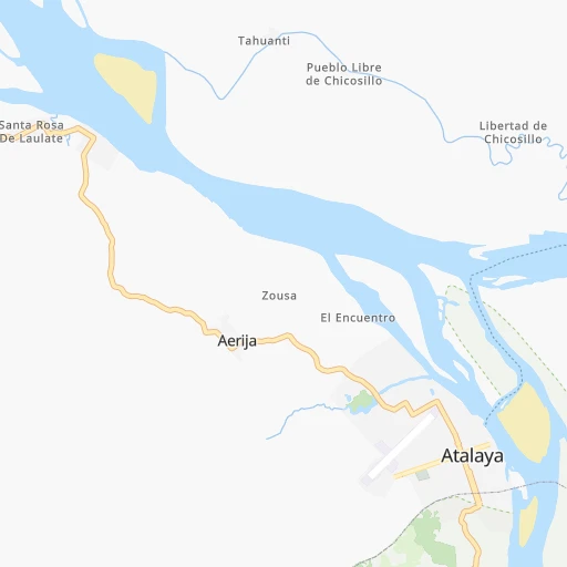
Roadmap (route) to go from Lieutenant General Gerardo Pérez Pinedo Airport to Sicaya detailed above, you can also see the course layout on the map.
While doing trip Lieutenant General Gerardo Pérez Pinedo (airport) - Sicaya by car, the calculated route ends at a distance , or more straight.
Distance and duration of the route between Lieutenant General Gerardo Pérez Pinedo (airport) and Sicaya
Calculation of distance and route from Sicaya to Lieutenant General Gerardo Pérez Pinedo (airport) :
219.8432.6 km9h19mn
Continue onto Fernando Belaunde Terry 0h1mn 280 mTurn sharp right onto Las Mohenas 0h1mn 493 mTurn left onto Dorian Campos 0h0mn 394 mTurn right onto Nicolás Vela 0h2mn 768 mTurn left onto Mario Denis Pezo 0h0mn 28 mTurn right onto Claveles 0h0mn 180 mTurn right onto PE-5SA 1h19mn 67.1 kmTurn left onto PE-5SA 2h42mn 84.3 kmTurn slight left onto Carretera Longitudinal de La Selva Sur 1h39mn 45.7 kmAt roundabout, take exit 2 onto PE-5S 0h0mn 477 mTurn slight right onto Avenida Marginal 0h14mn 12.6 kmTurn left 0h10mn 5.2 kmTurn right 0h3mn 1.7 kmTurn sharp right 0h1mn 782 mTurn left onto Jirón Augusto B. Leguía 0h12mn 10.5 kmTurn slight right onto Carretera Santa Ana 1h51mn 37.7 kmTurn right 0h0mn 220 mTurn slight right onto PE-24A 1h14mn 51.5 kmTurn right onto PE-24A 0h6mn 3.5 kmTurn right onto PE-24A 0h16mn 10.1 kmTurn left onto PE-24A 0h4mn 2.6 kmTurn sharp right onto JU-1180 0h25mn 12.5 kmTurn sharp right onto JU-1180 0h1mn 346 mTurn right onto JU-1180 0h21mn 10.7 kmTurn right onto JU-1186 0h11mn 6.0 kmTurn sharp right 0h0mn 80 mTurn right onto PE-24A 0h8mn 6.5 kmTurn right 0h3mn 1.8 kmTurn sharp right onto PE-24A 0h29mn 25.0 kmTurn slight left 0h1mn 686 mKeep right 0h2mn 1.0 kmTurn sharp right 0h0mn 5 mTurn sharp left onto PE-24A 0h9mn 7.6 kmTurn right onto PE-24A 0h3mn 2.4 kmTurn left onto PE-24A 0h1mn 384 mTurn right onto PE-24A 0h5mn 4.7 kmTurn left onto Jirón Bolognesi 0h1mn 1.2 kmTurn right onto Jirón Bolívar 0h0mn 84 mTurn left onto Jirón J. Chávez 0h2mn 980 mTurn left onto Carretera Longitudinal de la Sierra Sur 0h0mn 125 mTurn right 0h1mn 336 mTurn slight left 0h2mn 931 mTurn right 0h0mn 286 mTurn left 0h7mn 3.4 kmTurn left onto Carretera Central Margen Derecha 0h5mn 6.9 kmTurn right onto Pasaje Libertad 0h2mn 763 mTurn left onto Avenida Rodríguez Ruiz 0h2mn 1.8 kmTurn right 0h0mn 106 mArrive at destination 0h0mn 0 m
Travel from Lieutenant General Gerardo Pérez Pinedo (airport) (Junin) to a selection of major cities.
Distances from Lieutenant General Gerardo Pérez Pinedo Airport to biggest cities in Ucayali
Other major cities in country :
- Tumbes [24], 109,223 inhabitants. 1,086 km
- Talara [20], 99,074 inhabitants. 1,074 km
- Chosica [15], 88,606 inhabitants. 348 km
- Huaraz [02], 86,934 inhabitants. 433 km
- Cerro de Pasco [19], 78,910 inhabitants. 272 km
- Chulucanas [20], 68,835 inhabitants. 944 km
- San Isidro [15], 68,309 inhabitants. 390 km
- Huaral [15], 62,174 inhabitants. 385 km
- Pisco [11], 61,869 inhabitants. 425 km
- Catacaos [20], 57,304 inhabitants. 975 km
- Paita [20], 56,151 inhabitants. 1,025 km
- Abancay [03], 55,111 inhabitants. 337 km
- Huacho [15], 54,545 inhabitants. 422 km
- Moquegua [18], 54,517 inhabitants. 782 km
- Ilo [18], 53,476 inhabitants. 812 km
- Tingo Maria [10], 53,177 inhabitants. 292 km
- Jaen [06], 52,493 inhabitants. 788 km
- Tarma [12], 51,350 inhabitants. 224 km
Route from Sicaya to major cities (Peru).
- Distance Sicaya Lima190 km
- Distance Sicaya Arequipa632 km
- Distance Sicaya Callao200 km
- Distance Sicaya Trujillo599 km
- Distance Sicaya Chiclayo770 km
- Distance Sicaya Iquitos949 km
- Distance Sicaya Piura962 km
- Distance Sicaya Chimbote488 km
- Distance Sicaya Cusco396 km
- Distance Sicaya Pucallpa415 km
- Distance Sicaya Tacna858 km
- Distance Sicaya Santiago de Surco188 km
- Distance Sicaya Ica232 km
- Distance Sicaya Juliaca677 km
- Distance Sicaya Sullana992 km
- Distance Sicaya Chincha Alta179 km
- Distance Sicaya Huanuco256 km
- Distance Sicaya Ayacucho170 km
- Distance Sicaya Cajamarca647 km
- Distance Sicaya Puno709 km
Nearest cities to Lieutenant General Gerardo Pérez Pinedo (airport) :
- Huancayo, 376,657 inhabitants. 216 km
- Cusco, 312,140 inhabitants. 367 km
- Pucallpa, 310,750 inhabitants. 276 km
- Chincha Alta, 153,076 inhabitants. 394 km
- Huanuco, 147,959 inhabitants. 285 km
- Ayacucho, 140,033 inhabitants. 275 km
- Chosica, 88,606 inhabitants. 348 km
- Cerro de Pasco, 78,910 inhabitants. 272 km
- Pisco, 61,869 inhabitants. 425 km
- Abancay, 55,111 inhabitants. 337 km
- Tingo Maria, 53,177 inhabitants. 292 km
- Tarma, 51,350 inhabitants. 224 km
- Huancavelica, 41,576 inhabitants. 264 km
- La Oroya, 33,345 inhabitants. 249 km
- Imperial, 32,344 inhabitants. 383 km
- Nuevo Imperial, 32,344 inhabitants. 381 km
- Tocache, 29,029 inhabitants. 414 km
- Chaupimarca, 28,666 inhabitants. 297 km
- San Vicente de Canete, 25,517 inhabitants. 387 km
- Santa Ana, 25,145 inhabitants. 264 km
- Yanacancha, 23,175 inhabitants. 320 km
- Jauja, 21,057 inhabitants. 222 km
- Huanta, 18,627 inhabitants. 251 km
- Uchiza, 17,742 inhabitants. 389 km
- Andahuaylas, 17,444 inhabitants. 328 km
- Mala, 17,260 inhabitants. 379 km
- San Clemente, 15,815 inhabitants. 417 km
- Satipo, 15,532 inhabitants. 112 km
- Junin, 15,320 inhabitants. 248 km
- San Ramon, 14,708 inhabitants. 179 km
- Chilca, 12,884 inhabitants. 380 km
- Oxapampa, 12,000 inhabitants. 180 km
- Concepcion, 11,330 inhabitants. 215 km
- Villa Tupac Amaru, 11,159 inhabitants. 421 km
- Chupaca, 9,877 inhabitants. 223 km
- Calca, 9,179 inhabitants. 351 km
- Carhuamayo, 9,122 inhabitants. 249 km
- Campoverde, 8,945 inhabitants. 276 km
- San Jeronimo, 8,772 inhabitants. 215 km
- San Miguel, 8,400 inhabitants. 255 km
- Pilcomay, 8,169 inhabitants. 218 km
- Morococha, 7,890 inhabitants. 277 km
- Urubamba, 7,540 inhabitants. 338 km
- Villa Rica, 7,448 inhabitants. 164 km
- Talavera, 7,381 inhabitants. 328 km
- Ambo, 6,865 inhabitants. 275 km
- Perene, 6,844 inhabitants. 161 km
- Sicaya, 6,842 inhabitants. 220 km
- Mazamari, 6,826 inhabitants. 107 km
- Acolla, 6,805 inhabitants. 224 km
Location Lieutenant General Gerardo Pérez Pinedo (airport) (Ucayali) :
| Country flag |  |
| Location | Lieutenant General Gerardo Pérez Pinedo (airport) |
| State | Ucayali |
| County | Atalaya |
| Country | Peru |
| Country code / ISO 2 | PE |
| Latitude | -10.7291200 |
| Longitude | -73.7665000 |
| Altitude | 228 meters |
| Time zone | America/Lima |
Location Sicaya (Junin) :
| Country flag | |
| Location | Sicaya |
| State | Junin |
| County | Provincia de Huancayo |
| Country | Peru |
| Country code / ISO 2 | PE |
| Latitude | -12.0333300 |
| Longitude | -75.2833300 |
| Altitude | 0 meters |
| Time zone | America/Lima |


