


How to get from Vitória (airport) (Espírito Santo) to Nanuque (Minas Gerais)
Calculate route from Vitória (airport) (Espírito Santo, Brazil) to Nanuque (Minas Gerais, Brazil).
The flight distance (as the crow flies) between Vitória (airport) and Nanuque is 268.9 km.
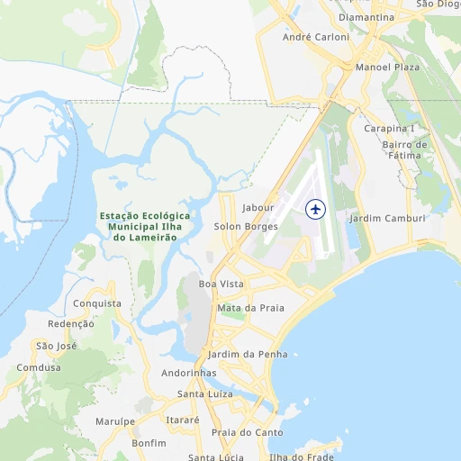
Roadmap (route) to go from Vitória Airport to Nanuque detailed above, you can also see the course layout on the map.
While doing trip Vitória (airport) - Nanuque by car, the calculated route ends at a distance , or more straight.
Distance and duration of the route between Vitória (airport) and Nanuque
Calculation of distance and route from Nanuque to Vitória (airport) :
268.9336.6 km6h39mn
Continue 0h0mn 122 mKeep right toward ES-020 0h3mn 2.8 kmKeep right and take BR-101 toward Serra-Sede, Salvador, Agroturismo, Praias 1h59mn 67.5 kmAt roundabout, take exit 1 onto Rodovia Governador Mário Covas 0h12mn 13.1 kmKeep right onto Rodovia Aracruz Córrego D'Água 0h0mn 31 mAt roundabout, take exit 2 onto Rodovia Aracruz Córrego D'Água 0h0mn 68 mTurn slight right onto Rodovia Governador Mário Covas 2h27mn 174.3 kmAt roundabout, take exit 2 onto Praça Castelo Branco 0h2mn 1.5 kmContinue onto Rodovia Estadual José Luiz da Costa 1h51mn 41.6 kmTurn left onto Estrada para Taquarinha 1h32mn 15.9 kmKeep right onto Avenida Vindilino Lima 0h18mn 9.5 kmKeep right onto Avenida Nanuque 0h0mn 47 mTurn slight right onto LMG-719, BR-439 0h14mn 7.5 kmTurn right onto Avenida Santos Dumont 0h2mn 1.9 kmAt roundabout, take exit 2 onto Avenida Geraldo Romano 0h0mn 405 mTurn left onto Rua Alvinópolis 0h0mn 181 mArrive at destination 0h0mn 0 m
Travel from Vitória (airport) (Minas Gerais) to a selection of major cities.
Distances from Vitória Airport to biggest cities in Espírito Santo
Other major cities in country :
- Sao Bernardo do Campo [27], 743,372 inhabitants. 752 km
- Campo Grande [11], 729,151 inhabitants. 1,498 km
- Jaboatao [30], 702,621 inhabitants. 1,460 km
- Osasco [27], 677,856 inhabitants. 764 km
- Santo Andre [27], 662,373 inhabitants. 748 km
- Joao Pessoa [17], 650,883 inhabitants. 1,576 km
- Jaboatao dos Guararapes [30], 630,008 inhabitants. 1,466 km
- Contagem [15], 627,123 inhabitants. 395 km
- Ribeirao Preto [27], 619,746 inhabitants. 790 km
- Sao Jose dos Campos [27], 613,764 inhabitants. 664 km
- Uberlandia [15], 563,536 inhabitants. 851 km
- Sorocaba [27], 558,862 inhabitants. 824 km
- Cuiaba [14], 521,934 inhabitants. 1,752 km
- Aparecida de Goiania [29], 510,770 inhabitants. 1,020 km
- Aracaju [28], 490,175 inhabitants. 1,096 km
- Feira de Santana [05], 481,911 inhabitants. 901 km
- Londrina [18], 471,832 inhabitants. 1,174 km
- Juiz de Fora [15], 470,193 inhabitants. 360 km
- Belford Roxo [21], 466,096 inhabitants. 426 km
- Joinville [26], 461,304 inhabitants. 1,104 km
Route from Nanuque to major cities (Brazil).
- Distance Nanuque Sao Paulo912 km
- Distance Nanuque Rio de Janeiro637 km
- Distance Nanuque Salvador577 km
- Distance Nanuque Fortaleza1,584 km
- Distance Nanuque Brasilia839 km
- Distance Nanuque Curitiba1,250 km
- Distance Nanuque Manaus2,702 km
- Distance Nanuque Recife1,240 km
- Distance Nanuque Belem2,030 km
- Distance Nanuque Porto Alegre1,749 km
- Distance Nanuque Goiania955 km
- Distance Nanuque Guarulhos898 km
- Distance Nanuque Campinas899 km
- Distance Nanuque Nova Iguacu636 km
- Distance Nanuque Maceio1,038 km
- Distance Nanuque Sao Luis1,758 km
- Distance Nanuque Duque de Caxias631 km
- Distance Nanuque Natal1,453 km
- Distance Nanuque Teresina1,444 km
- Distance Nanuque Sao Bernardo do Campo918 km
Nearest cities to Vitória (airport) :
- Rio de Janeiro, 6,023,699 inhabitants. 420 km
- Niteroi, 456,456 inhabitants. 413 km
- Vila Velha, 394,930 inhabitants. 8 km
- Serra, 394,153 inhabitants. 15 km
- Campos dos Goytacazes, 387,417 inhabitants. 199 km
- Vitoria, 312,656 inhabitants. 9 km
- Petropolis, 272,691 inhabitants. 390 km
- Governador Valadares, 250,878 inhabitants. 234 km
- Ipatinga, 228,746 inhabitants. 251 km
- Cachoeiro de Itapemirim, 187,019 inhabitants. 108 km
- Itaborai, 182,498 inhabitants. 384 km
- Nova Friburgo, 153,361 inhabitants. 324 km
- Macae, 143,029 inhabitants. 283 km
- Teresopolis, 123,979 inhabitants. 368 km
- Araruama, 109,637 inhabitants. 361 km
- Cabo Frio, 108,239 inhabitants. 344 km
- Linhares, 105,075 inhabitants. 99 km
- Colatina, 101,190 inhabitants. 88 km
- Teofilo Otoni, 101,170 inhabitants. 296 km
- Guarapari, 100,925 inhabitants. 51 km
- Coronel Fabriciano, 100,916 inhabitants. 259 km
- Rio das Ostras, 100,000 inhabitants. 306 km
- Itabira, 99,496 inhabitants. 316 km
- Uba, 97,828 inhabitants. 293 km
- Timoteo, 91,722 inhabitants. 259 km
- Muriae, 91,173 inhabitants. 237 km
- Itaperuna, 84,435 inhabitants. 197 km
- Marica, 79,551 inhabitants. 396 km
- Sao Mateus, 77,117 inhabitants. 177 km
- Joao Monlevade, 72,762 inhabitants. 306 km
- Tres Rios, 71,944 inhabitants. 367 km
- Vicosa, 68,680 inhabitants. 276 km
- Cataguases, 62,618 inhabitants. 281 km
- Saquarema, 62,056 inhabitants. 375 km
- Caratinga, 60,066 inhabitants. 201 km
- Aracruz, 58,271 inhabitants. 49 km
- Nova Vicosa, 55,980 inhabitants. 280 km
- Viana, 55,122 inhabitants. 26 km
- Sao Pedro da Aldeia, 55,014 inhabitants. 343 km
- Manhuacu, 54,607 inhabitants. 182 km
- Ponte Nova, 48,187 inhabitants. 274 km
- Leopoldina, 46,742 inhabitants. 283 km
- Cachoeiras de Macacu, 46,177 inhabitants. 347 km
- Nanuque, 37,824 inhabitants. 269 km
- Rio Bonito, 35,997 inhabitants. 364 km
- Alem Paraiba, 33,907 inhabitants. 310 km
- Santo Antonio de Padua, 33,076 inhabitants. 243 km
- Guapimirim, 31,202 inhabitants. 377 km
- Bom Jesus do Itabapoana, 30,821 inhabitants. 175 km
- Visconde do Rio Branco, 29,009 inhabitants. 279 km
Location Vitória (airport) (Espírito Santo) :
| Country flag |  |
| Location | Vitória (airport) |
| State | Espírito Santo |
| County | Vitória |
| Country | Brazil |
| Country code / ISO 2 | BR |
| Latitude | -20.2580600 |
| Longitude | -40.2863900 |
| Altitude | 3 meters |
| Time zone | America/Sao_Paulo |
Location Nanuque (Minas Gerais) :
| Country flag | |
| Location | Nanuque |
| State | Minas Gerais |
| County | Nanuque |
| Country | Brazil |
| Country code / ISO 2 | BR |
| Latitude | -17.8391700 |
| Longitude | -40.3538900 |
| Altitude | 0 meters |
| Time zone | America/Sao_Paulo |