
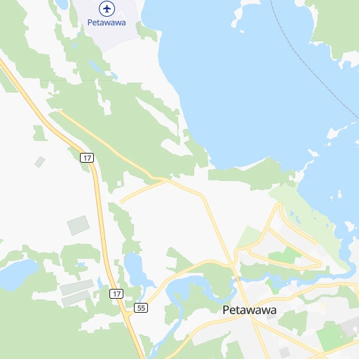
How to get from Petawawa (Ontario) to Red Deer (Alberta)
Calculate route from Petawawa (Ontario, Canada) to Red Deer (Alberta, Canada).
The flight distance (as the crow flies) between Petawawa and Red Deer is 2,719.1 km.
Roadmap (route) to go from Petawawa to Red Deer detailed above, you can also see the course layout on the map.
While doing trip Petawawa - Red Deer by car, the calculated route ends at a distance , or more straight.
Distance and duration of the route between Petawawa and Red Deer
Calculation of distance and route from Red Deer to Petawawa :
2,719.13,213.3 km39h50mn
Continue onto Edith Street 0h0mn 40 mTurn right onto Doran Road 0h0mn 236 mTurn left onto Petawawa Boulevard 0h1mn 1.1 kmTurn left onto Paquette Road 0h2mn 2.3 kmKeep right 0h0mn 170 mTurn slight right onto Highway 17 2h38mn 131.0 kmAt roundabout, take exit 2 onto McConnell Street 1h45mn 58.7 kmKeep right and take 11, 17 toward North Bay 2h41mn 128.4 kmContinue onto Brady Street 0h1mn 809 mTurn slight right onto Brady Street 0h1mn 792 mContinue onto Douglas Street 0h0mn 353 mTurn left onto Lorne Street 0h10mn 11.2 kmKeep right and take 17 West toward Sault Ste. Marie 3h16mn 259.3 kmTurn left onto Bar River West 0h0mn 86 mKeep right 0h0mn 152 mTurn slight right onto Highway 17B 0h20mn 20.7 kmContinue onto Trunk Road 0h4mn 4.2 kmKeep right 0h0mn 61 mTurn slight right onto South Market Street 0h5mn 4.9 kmTurn left onto North Street 0h1mn 398 mTurn right onto Cathcart Street 0h1mn 571 mTurn left onto Huron Street 0h0mn 190 mTurn sharp right onto International Crossing 0h0mn 359 mContinue onto Sault Ste. Marie International Bridge 0h12mn 16.6 kmKeep right and take M 28 toward Newberry, Munising 0h1mn 690 mTurn right onto M 28 2h56mn 179.1 kmTurn left onto East Superior Street 0h0mn 142 mTurn right onto Birch Street 0h0mn 115 mTurn left onto East Munising Avenue 0h3mn 2.3 kmTurn sharp left onto Portage Street 0h4mn 2.2 kmTurn left onto West State Highway M 28 1h36mn 55.2 kmTurn right onto US 41, M 28 0h6mn 6.9 kmAt roundabout, take exit 2 onto Marquette Bypass 0h1mn 955 mAt roundabout, take exit 2 onto Marquette Bypass 0h0mn 307 mAt roundabout, take exit 2 onto Marquette Bypass 0h3mn 4.2 kmAt roundabout, take exit 2 onto US-41/M-28 0h1mn 921 mAt roundabout, take exit 2 onto US-41/M-28 0h13mn 16.4 kmAt roundabout, take exit 2 onto Palms Avenue 1h47mn 65.8 kmTurn left onto US 141, M 28 1h20mn 124.5 kmTurn sharp right onto North Chicago Mine Road 0h3mn 2.1 kmTurn right onto US 2 1h4mn 78.3 kmTurn slight right onto Lake Shore Drive West 0h6mn 5.4 kmKeep left onto Major Richard I. Bong Memorial Highway and take US 2 West toward Superior, Duluth 0h0mn 168 mAt roundabout, take exit 2 onto Major Richard I. Bong Memorial Highway 1h16mn 96.5 kmTurn left onto Lenroot Highway 0h5mn 3.9 kmAt roundabout, take exit 2 onto Major Richard I. Bong Memorial Highway 0h3mn 4.1 kmTurn left onto US 2 0h3mn 4.2 kmKeep right onto US 2 2h44mn 122.4 kmTurn left onto Northeast 4th Street 0h22mn 25.8 kmTurn right onto MN 46 1h15mn 75.0 kmTurn left onto Voyageur Highway 0h4mn 4.8 kmTurn right onto MN 1 0h8mn 7.8 kmTurn right onto Highway 72 Northeast 1h9mn 96.1 kmTurn left onto East Main Street 1h51mn 62.9 kmTurn right onto MOM's Way 0h8mn 10.2 kmKeep left onto MOM's Way 1h41mn 60.7 kmTurn right onto Provincial Road 210 1h40mn 55.5 kmTurn right onto Principale Street 0h2mn 1.6 kmTurn left onto Provincial Road 210 0h12mn 18.1 kmTurn left onto Centrale Avenue 0h3mn 2.6 kmKeep right 0h2mn 3.1 kmKeep right and take PTH 1 toward Winnipeg 0h24mn 34.8 kmKeep right 0h3mn 3.2 kmTurn left onto Chemin Dawson Road North 0h1mn 911 mTurn left onto Rue Marion Street 0h5mn 4.3 kmTurn left onto Broadway 0h3mn 2.3 kmTurn left onto Portage Avenue 1h55mn 77.8 kmKeep right and take 1A toward Portage la Prairie 0h10mn 9.8 kmAt roundabout, take exit 1 5h36mn 454.5 kmKeep right and take 46 toward Regina, Balgonie, Edenwold 0h1mn 802 mKeep right 0h17mn 21.3 kmTurn right onto 9th Avenue North 0h2mn 1.7 kmContinue 0h1mn 909 mKeep right and take 6 North toward Saskatoon 0h0mn 504 mKeep right toward 6 North 0h1mn 798 mKeep right onto 11A and take 11A North toward Lumsden, Saskatoon 2h43mn 169.4 kmTurn left 0h0mn 230 mTurn right 0h4mn 3.6 kmTurn left onto Highway 15 1h37mn 54.9 kmTurn left onto Mckenzie Street 1h45mn 66.8 kmContinue 0h1mn 1.4 kmKeep right 0h11mn 13.2 kmTurn right 0h0mn 59 mTurn sharp left onto Highway 7 1h6mn 97.0 kmTurn right 0h3mn 3.5 kmTurn left 0h1mn 1.6 kmTurn right 0h3mn 3.1 kmTurn right 0h1mn 1.6 kmTurn left 0h1mn 1.6 kmTurn right 0h4mn 4.9 kmTurn left 0h3mn 3.2 kmTurn right 0h1mn 1.6 kmTurn left 0h2mn 1.9 kmContinue onto 317 0h1mn 1.3 kmContinue onto Loverna Access Road 0h15mn 18.1 kmTurn left onto Loverna Access Road 0h0mn 56 mTurn right onto Loverna Access Road 0h1mn 1.5 kmTurn left onto 1st Avenue 0h2mn 852 mTurn right 0h18mn 21.2 kmTurn left onto Highway 51 0h29mn 43.8 kmContinue onto Buffalo Trail 0h12mn 17.3 kmContinue onto Highway 12 2h38mn 142.3 kmContinue onto 50 Street 0h1mn 412 mTurn left onto 47 Avenue 0h2mn 1.5 kmTurn slight right onto 50 Avenue 0h14mn 19.5 kmTurn left onto Highway 11 1h38mn 54.8 kmTurn left onto Rutherford Drive 0h1mn 403 mTurn right onto Rollis Street 0h0mn 318 mTurn left onto 30 Avenue 0h0mn 345 mKeep right 0h3mn 2.5 kmTurn sharp left onto 46 Avenue 0h0mn 227 mArrive at destination 0h0mn 0 m
Travel from Petawawa (Alberta) to a selection of major cities.
Distances from Petawawa to biggest cities in Ontario
- St. Catharines,131,989 inhabitants.341 km
- Cambridge,120,372 inhabitants.371 km
- Guelph,115,760 inhabitants.352 km
- East York,115,365 inhabitants.294 km
- Kingston,114,195 inhabitants.196 km
- Thunder Bay,99,334 inhabitants.947 km
- Waterloo,97,475 inhabitants.372 km
- Ajax,90,167 inhabitants.266 km
- Pickering,87,838 inhabitants.266 km
- Brantford,87,759 inhabitants.388 km
- Milton,84,362 inhabitants.335 km
- Sarnia,82,998 inhabitants.521 km
- Niagara Falls,82,000 inhabitants.342 km
- Willowdale,79,440 inhabitants.290 km
- Peterborough,75,877 inhabitants.195 km
- Sault Ste. Marie,74,948 inhabitants.548 km
- Newmarket,74,295 inhabitants.268 km
- Norfolk County,60,847 inhabitants.421 km
- Welland,50,331 inhabitants.360 km
- North Bay,50,170 inhabitants.175 km
Other major cities in country :
- Sherbrooke [10], 129,447 inhabitants. 422 km
- Anmore [02], 126,456 inhabitants. 3,389 km
- Levis [10], 126,396 inhabitants. 480 km
- Kelowna [02], 125,109 inhabitants. 3,139 km
- Trois-Rivieres [10], 119,693 inhabitants. 369 km
- Coquitlam [02], 114,565 inhabitants. 3,383 km
- Sydney [07], 105,968 inhabitants. 1,319 km
- Delta [02], 101,668 inhabitants. 3,397 km
- Dartmouth [07], 101,343 inhabitants. 1,081 km
- St. John's [05], 99,182 inhabitants. 1,876 km
- Terrebonne [10], 94,703 inhabitants. 283 km
- Saint John [04], 87,857 inhabitants. 876 km
- Moncton [04], 87,467 inhabitants. 965 km
- Nanaimo [02], 84,905 inhabitants. 3,470 km
- Saint-Laurent [10], 77,391 inhabitants. 284 km
- Chilliwack [02], 77,000 inhabitants. 3,328 km
- Repentigny [10], 76,237 inhabitants. 298 km
- Fort McMurray [01], 76,000 inhabitants. 2,625 km
- La Haute-Saint-Charles [10], 74,070 inhabitants. 467 km
- Red Deer [01], 73,593 inhabitants. 2,724 km
Route from Red Deer to major cities (Canada).
- Distance Red Deer Toronto2,703 km
- Distance Red Deer Montreal2,996 km
- Distance Red Deer Ottawa2,858 km
- Distance Red Deer Mississauga2,694 km
- Distance Red Deer North York2,699 km
- Distance Red Deer Winnipeg1,192 km
- Distance Red Deer Scarborough2,710 km
- Distance Red Deer Vancouver736 km
- Distance Red Deer Quebec3,089 km
- Distance Red Deer Hamilton2,701 km
- Distance Red Deer Brampton2,680 km
- Distance Red Deer Surrey726 km
- Distance Red Deer Laval2,986 km
- Distance Red Deer Halifax3,724 km
- Distance Red Deer Etobicoke2,696 km
- Distance Red Deer London2,625 km
- Distance Red Deer Okanagan440 km
- Distance Red Deer Victoria802 km
- Distance Red Deer Windsor2,550 km
- Distance Red Deer Markham2,703 km
Nearest cities to Petawawa :
- Toronto, 2,600,000 inhabitants. 297 km
- Ottawa, 812,129 inhabitants. 134 km
- Mississauga, 668,549 inhabitants. 319 km
- North York, 636,000 inhabitants. 291 km
- Scarborough, 600,000 inhabitants. 283 km
- Hamilton, 519,949 inhabitants. 358 km
- Brampton, 433,806 inhabitants. 315 km
- Etobicoke, 347,948 inhabitants. 308 km
- Markham, 261,573 inhabitants. 275 km
- Oshawa, 247,989 inhabitants. 254 km
- Gatineau, 242,124 inhabitants. 131 km
- Vaughan, 238,866 inhabitants. 288 km
- Richmond Hill, 185,541 inhabitants. 282 km
- Barrie, 182,041 inhabitants. 251 km
- Nepean, 180,000 inhabitants. 134 km
- Oakville, 165,697 inhabitants. 332 km
- Burlington, 164,415 inhabitants. 345 km
- St. Catharines, 131,989 inhabitants. 341 km
- Guelph, 115,760 inhabitants. 352 km
- East York, 115,365 inhabitants. 294 km
- Kingston, 114,195 inhabitants. 196 km
- Ajax, 90,167 inhabitants. 266 km
- Pickering, 87,838 inhabitants. 266 km
- Brantford, 87,759 inhabitants. 388 km
- Milton, 84,362 inhabitants. 335 km
- Niagara Falls, 82,000 inhabitants. 342 km
- Willowdale, 79,440 inhabitants. 290 km
- Peterborough, 75,877 inhabitants. 195 km
- Newmarket, 74,295 inhabitants. 268 km
- Welland, 50,331 inhabitants. 360 km
- North Bay, 50,170 inhabitants. 175 km
- Belleville, 49,454 inhabitants. 192 km
- Cornwall, 48,821 inhabitants. 222 km
- Quinte West, 42,697 inhabitants. 192 km
- Ancaster, 33,232 inhabitants. 367 km
- Orangeville, 32,640 inhabitants. 313 km
- Midland, 31,502 inhabitants. 240 km
- Val-d'Or, 31,123 inhabitants. 248 km
- Orillia, 30,178 inhabitants. 221 km
- Prince Edward, 25,496 inhabitants. 211 km
- Rouyn-Noranda, 24,023 inhabitants. 292 km
- Brockville, 23,886 inhabitants. 191 km
- Keswick, 21,000 inhabitants. 251 km
- Clarence-Rockland, 20,790 inhabitants. 159 km
- Lindsay, 20,354 inhabitants. 206 km
- Huntsville, 19,579 inhabitants. 163 km
- Port Colborne, 18,599 inhabitants. 368 km
- Thorold, 18,224 inhabitants. 345 km
- Cobourg, 18,099 inhabitants. 226 km
- Amos, 17,918 inhabitants. 304 km
Location Petawawa (Ontario) :
| Country flag |  |
| Location | Petawawa |
| State | Ontario |
| County | |
| Country | Canada |
| Country code / ISO 2 | CA |
| Latitude | 45.8945200 |
| Longitude | -77.2800700 |
| Altitude | 0 meters |
| Time zone | America/Toronto |
Location Red Deer (Alberta) :
| Country flag | |
| Location | Red Deer |
| State | Alberta |
| County | |
| Country | Canada |
| Country code / ISO 2 | CA |
| Latitude | 52.2668200 |
| Longitude | -113.8020000 |
| Altitude | 0 meters |
| Time zone | America/Edmonton |


