
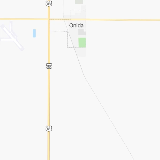


How to get from Onida Municipal (airport) (South Dakota) to Mitchell (South Dakota)
Calculate route from Onida Municipal (airport) (South Dakota, United States) to Mitchell (South Dakota, United States).
The flight distance (as the crow flies) between Onida Municipal (airport) and Mitchell is 198.5 km.
Roadmap (route) to go from Onida Municipal Airport to Mitchell detailed above, you can also see the course layout on the map.
While doing trip Onida Municipal (airport) - Mitchell by car, the calculated route ends at a distance , or more straight.
Distance and duration of the route between Onida Municipal (airport) and Mitchell
Calculation of distance and route from Mitchell to Onida Municipal (airport) :
198.5273.6 km4h32mn
Continue onto 303rd Avenue 0h1mn 558 mTurn right onto 185th Street 0h2mn 1.6 kmTurn right onto US 83 0h19mn 21.7 kmTurn left onto 198th Street 0h2mn 1.6 kmTurn right onto 306th Avenue 0h0mn 123 mTurn sharp left onto US 14 1h41mn 48.4 kmTurn right onto Iowa Avenue North 1h30mn 30.2 kmContinue onto SD 34, SD 47 0h18mn 19.9 kmContinue onto SD Highway 47 0h1mn 945 mContinue onto BIA Route 4 0h15mn 12.3 kmTurn right onto SD 50 0h19mn 23.3 kmTurn left onto East Mott Avenue 0h0mn 101 mTurn right onto North Sanborn Street 0h1mn 495 mTurn left onto East King Avenue 0h4mn 5.2 kmTurn left onto I 90 Business, SD 50 1h53mn 103.0 kmKeep right onto I 90 Business 0h1mn 587 mTurn left onto South Ohlman Street 0h1mn 1.3 kmKeep right 0h0mn 92 mContinue onto West Havens Avenue 0h2mn 1.3 kmTurn left onto South Sanborn Boulevard 0h1mn 811 mTurn left onto West 1st Avenue 0h0mn 10 mArrive at destination 0h0mn 0 m
Travel from Onida Municipal (airport) (South Dakota) to a selection of major cities.
Distances from Onida Municipal Airport to biggest cities in South Dakota
Other major cities in country :
- Charlotte [NC], 827,097 inhabitants. 1,945 km
- Seattle [WA], 684,451 inhabitants. 1,738 km
- Denver [CO], 682,545 inhabitants. 683 km
- El Paso [TX], 681,124 inhabitants. 1,544 km
- Detroit [MI], 677,116 inhabitants. 1,399 km
- Boston [MA], 667,137 inhabitants. 2,346 km
- Memphis [TN], 655,770 inhabitants. 1,364 km
- New South Memphis [TN], 641,608 inhabitants. 1,370 km
- Portland [OR], 632,309 inhabitants. 1,770 km
- Oklahoma City [OK], 631,346 inhabitants. 1,051 km
- Las Vegas [NV], 623,747 inhabitants. 1,585 km
- Baltimore [MD], 621,849 inhabitants. 2,026 km
- Washington, D.C. [DC], 601,723 inhabitants. 2,012 km
- Milwaukee [WI], 600,155 inhabitants. 995 km
- South Boston [MA], 571,281 inhabitants. 2,347 km
- Albuquerque [NM], 559,121 inhabitants. 1,207 km
- Tucson [AZ], 531,641 inhabitants. 1,676 km
- Nashville [TN], 530,852 inhabitants. 1,472 km
- Fresno [CA], 520,052 inhabitants. 1,874 km
- Sacramento [CA], 490,712 inhabitants. 1,899 km
Route from Mitchell to major cities (United States).
- Distance Mitchell New York City2,001 km
- Distance Mitchell Los Angeles2,047 km
- Distance Mitchell Chicago872 km
- Distance Mitchell Brooklyn2,008 km
- Distance Mitchell Houston1,570 km
- Distance Mitchell Queens2,016 km
- Distance Mitchell Philadelphia1,936 km
- Distance Mitchell Phoenix1,669 km
- Distance Mitchell Manhattan2,002 km
- Distance Mitchell San Antonio1,591 km
- Distance Mitchell San Diego2,065 km
- Distance Mitchell The Bronx2,008 km
- Distance Mitchell Dallas1,221 km
- Distance Mitchell San Jose2,131 km
- Distance Mitchell Austin1,497 km
- Distance Mitchell Jacksonville2,075 km
- Distance Mitchell San Francisco2,151 km
- Distance Mitchell Columbus1,312 km
- Distance Mitchell Fort Worth1,224 km
- Distance Mitchell Indianapolis1,078 km
Nearest cities to Onida Municipal (airport) :
- Bismarck, 71,167 inhabitants. 240 km
- Aberdeen, 28,102 inhabitants. 153 km
- Norfolk, 24,366 inhabitants. 368 km
- Dickinson, 23,765 inhabitants. 320 km
- Watertown, 22,073 inhabitants. 237 km
- Mandan, 21,382 inhabitants. 244 km
- Mitchell, 15,669 inhabitants. 199 km
- Jamestown, 15,422 inhabitants. 268 km
- Yankton, 14,557 inhabitants. 298 km
- Pierre, 14,002 inhabitants. 42 km
- Huron, 13,313 inhabitants. 154 km
- Box Elder, 9,289 inhabitants. 245 km
- Alliance, 8,522 inhabitants. 366 km
- Madison, 7,258 inhabitants. 250 km
- Valley City, 6,669 inhabitants. 296 km
- Chadron, 5,775 inhabitants. 313 km
- O'Neill, 3,653 inhabitants. 276 km
- Lincoln, 3,519 inhabitants. 234 km
- Mobridge, 3,466 inhabitants. 96 km
- Beulah, 3,393 inhabitants. 313 km
- Pine Ridge, 3,308 inhabitants. 271 km
Location Onida Municipal (airport) (South Dakota) :
| Country flag |  |
| Location | Onida Municipal (airport) |
| State | South Dakota |
| County | Sully County |
| Country | United States |
| Country code / ISO 2 | US |
| Latitude | 44.7026800 |
| Longitude | -100.1009300 |
| Altitude | 570 meters |
| Time zone | America/Chicago |
Location Mitchell (South Dakota) :
| Country flag | |
| Location | Mitchell |
| State | South Dakota |
| County | Davison County |
| Country | United States |
| Country code / ISO 2 | US |
| Latitude | 43.7094300 |
| Longitude | -98.0298000 |
| Altitude | 400 meters |
| Time zone | America/Chicago |

