


How to get from Merry (airport) (Nebraska) to Box Elder (South Dakota)
Calculate route from Merry (airport) (Nebraska, United States) to Box Elder (South Dakota, United States).
The flight distance (as the crow flies) between Merry (airport) and Box Elder is 266.5 km.
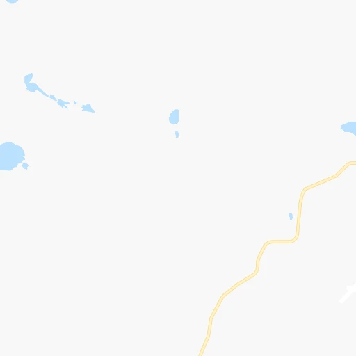
Roadmap (route) to go from Merry Airport to Box Elder detailed above, you can also see the course layout on the map.
While doing trip Merry (airport) - Box Elder by car, the calculated route ends at a distance , or more straight.
Distance and duration of the route between Merry (airport) and Box Elder
Calculation of distance and route from Box Elder to Merry (airport) :
266.5340.0 km4h8mn
Continue onto Merrihew Lane 0h2mn 3.1 kmTurn right onto South Ashby 0h12mn 15.9 kmTurn left onto NE 2 0h29mn 45.0 kmTurn right onto State Highway 250 1h53mn 76.6 kmTurn left onto 580 Road 0h1mn 1.6 kmTurn right onto 340 Lane 0h26mn 38.4 kmContinue onto US 18 0h25mn 27.0 kmTurn right onto Lone Man Road 1h13mn 93.9 kmTurn right onto North Heartland Expressway 0h14mn 22.1 kmKeep right onto SD 79 0h0mn 332 mKeep right onto SD 79 0h6mn 8.6 kmKeep right 0h2mn 2.8 kmKeep right and drive toward Box Elder, Elisworth AirForce Base, Commercial Gate 0h3mn 4.1 kmTurn right onto South Ellsworth Road 0h0mn 113 mTurn left onto Front Street 0h0mn 198 mArrive at destination 0h0mn 0 m
Travel from Merry (airport) (South Dakota) to a selection of major cities.
Distances from Merry Airport to biggest cities in Nebraska
Other major cities in country :
- Charlotte [NC], 827,097 inhabitants. 1,972 km
- Seattle [WA], 684,451 inhabitants. 1,730 km
- Denver [CO], 682,545 inhabitants. 350 km
- El Paso [TX], 681,124 inhabitants. 1,196 km
- Detroit [MI], 677,116 inhabitants. 1,556 km
- Boston [MA], 667,137 inhabitants. 2,535 km
- Memphis [TN], 655,770 inhabitants. 1,274 km
- New South Memphis [TN], 641,608 inhabitants. 1,278 km
- Portland [OR], 632,309 inhabitants. 1,714 km
- Oklahoma City [OK], 631,346 inhabitants. 808 km
- Las Vegas [NV], 623,747 inhabitants. 1,305 km
- Baltimore [MD], 621,849 inhabitants. 2,151 km
- Washington, D.C. [DC], 601,723 inhabitants. 2,128 km
- Milwaukee [WI], 600,155 inhabitants. 1,157 km
- South Boston [MA], 571,281 inhabitants. 2,536 km
- Albuquerque [NM], 559,121 inhabitants. 860 km
- Tucson [AZ], 531,641 inhabitants. 1,337 km
- Nashville [TN], 530,852 inhabitants. 1,452 km
- Fresno [CA], 520,052 inhabitants. 1,636 km
- Sacramento [CA], 490,712 inhabitants. 1,700 km
Route from Box Elder to major cities (United States).
- Distance Box Elder New York City2,405 km
- Distance Box Elder Los Angeles1,719 km
- Distance Box Elder Chicago1,279 km
- Distance Box Elder Brooklyn2,412 km
- Distance Box Elder Houston1,736 km
- Distance Box Elder Queens2,420 km
- Distance Box Elder Philadelphia2,341 km
- Distance Box Elder Phoenix1,419 km
- Distance Box Elder Manhattan2,406 km
- Distance Box Elder San Antonio1,684 km
- Distance Box Elder San Diego1,762 km
- Distance Box Elder The Bronx2,412 km
- Distance Box Elder Dallas1,373 km
- Distance Box Elder San Jose1,753 km
- Distance Box Elder Austin1,611 km
- Distance Box Elder Jacksonville2,428 km
- Distance Box Elder San Francisco1,768 km
- Distance Box Elder Columbus1,718 km
- Distance Box Elder Fort Worth1,362 km
- Distance Box Elder Indianapolis1,478 km
Nearest cities to Merry (airport) :
- Aurora, 359,407 inhabitants. 342 km
- Centennial, 109,741 inhabitants. 357 km
- Greeley, 100,883 inhabitants. 284 km
- Rapid City, 73,569 inhabitants. 269 km
- Cheyenne, 63,335 inhabitants. 255 km
- Castle Rock, 55,591 inhabitants. 372 km
- Parker, 49,550 inhabitants. 355 km
- Brighton, 37,585 inhabitants. 322 km
- Kearney, 33,021 inhabitants. 270 km
- Castlewood, 25,271 inhabitants. 358 km
- North Platte, 24,194 inhabitants. 127 km
- Windsor, 21,751 inhabitants. 294 km
- Evans, 21,383 inhabitants. 286 km
- Hays, 21,092 inhabitants. 399 km
- Johnstown, 14,896 inhabitants. 303 km
- Scottsbluff, 14,802 inhabitants. 145 km
- Sterling, 14,104 inhabitants. 175 km
- Pierre, 14,002 inhabitants. 306 km
- Lone Tree, 13,175 inhabitants. 359 km
- Black Forest, 13,116 inhabitants. 396 km
- Fort Morgan, 11,319 inhabitants. 239 km
- Spearfish, 11,283 inhabitants. 332 km
- Cherry Creek, 11,120 inhabitants. 352 km
- The Pinery, 10,517 inhabitants. 359 km
- Castle Pines North, 10,360 inhabitants. 366 km
- Lexington, 10,075 inhabitants. 218 km
- Box Elder, 9,289 inhabitants. 267 km
- Stonegate, 8,962 inhabitants. 356 km
- Woodmoor, 8,741 inhabitants. 395 km
- Alliance, 8,522 inhabitants. 83 km
- Gering, 8,334 inhabitants. 145 km
- Rapid Valley, 8,260 inhabitants. 264 km
- Fort Lupton, 7,822 inhabitants. 314 km
- McCook, 7,580 inhabitants. 215 km
- Sidney, 6,942 inhabitants. 120 km
- Sturgis, 6,688 inhabitants. 311 km
- Air Force Academy, 6,680 inhabitants. 406 km
- Torrington, 6,669 inhabitants. 189 km
- Gleneagle, 6,611 inhabitants. 399 km
- Monument, 6,420 inhabitants. 397 km
- Milliken, 6,388 inhabitants. 300 km
- Ranchettes, 5,798 inhabitants. 250 km
- Chadron, 5,775 inhabitants. 139 km
- Belle Fourche, 5,696 inhabitants. 349 km
- Holdrege, 5,561 inhabitants. 266 km
- Brush, 5,459 inhabitants. 229 km
- Colby, 5,417 inhabitants. 285 km
- Lochbuie, 5,390 inhabitants. 313 km
- Dove Valley, 5,243 inhabitants. 354 km
- Eaton, 4,928 inhabitants. 277 km
Location Merry (airport) (Nebraska) :
| Country flag |  |
| Location | Merry (airport) |
| State | Nebraska |
| County | Grant County |
| Country | United States |
| Country code / ISO 2 | US |
| Latitude | 41.8663700 |
| Longitude | -101.9174000 |
| Altitude | 1171 meters |
| Time zone | America/Denver |
Location Box Elder (South Dakota) :
| Country flag | |
| Location | Box Elder |
| State | South Dakota |
| County | Pennington County |
| Country | United States |
| Country code / ISO 2 | US |
| Latitude | 44.1124900 |
| Longitude | -103.0682300 |
| Altitude | 925 meters |
| Time zone | America/Denver |


