

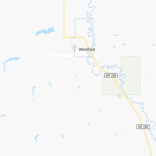


How to get from Winifred (airport) (Montana) to Lewistown (Montana)
Calculate route from Winifred (airport) (Montana, United States) to Lewistown (Montana, United States).
The flight distance (as the crow flies) between Winifred (airport) and Lewistown is 54.9 km.
Roadmap (route) to go from Winifred Airport to Lewistown detailed above, you can also see the course layout on the map.
While doing trip Winifred (airport) - Lewistown by car, the calculated route ends at a distance , or more straight.
Distance and duration of the route between Winifred (airport) and Lewistown
Calculation of distance and route from Lewistown to Winifred (airport) :
54.963.6 km1h5mn
Continue onto Paradise Road 0h2mn 774 mTurn slight left onto 2nd Avenue 0h1mn 378 mTurn right 0h0mn 136 mTurn right onto Truck Bypass 1h38mn 37.8 kmTurn right onto US 191 0h23mn 23.3 kmTurn left onto 1st Avenue North 0h0mn 496 mTurn right onto West Main Street 0h1mn 553 mTurn left onto 6th Avenue South 0h0mn 120 mArrive at destination 0h0mn 0 m
Travel from Winifred (airport) (Montana) to a selection of major cities.
Distances from Winifred Airport to biggest cities in Montana
Other major cities in country :
- Charlotte [NC], 827,097 inhabitants. 2,728 km
- Seattle [WA], 684,451 inhabitants. 971 km
- Denver [CO], 682,545 inhabitants. 939 km
- El Paso [TX], 681,124 inhabitants. 1,776 km
- Detroit [MI], 677,116 inhabitants. 2,144 km
- Boston [MA], 667,137 inhabitants. 3,042 km
- Memphis [TN], 655,770 inhabitants. 2,115 km
- New South Memphis [TN], 641,608 inhabitants. 2,120 km
- Portland [OR], 632,309 inhabitants. 1,041 km
- Oklahoma City [OK], 631,346 inhabitants. 1,666 km
- Las Vegas [NV], 623,747 inhabitants. 1,353 km
- Baltimore [MD], 621,849 inhabitants. 2,781 km
- Washington, D.C. [DC], 601,723 inhabitants. 2,771 km
- Milwaukee [WI], 600,155 inhabitants. 1,749 km
- South Boston [MA], 571,281 inhabitants. 3,044 km
- Albuquerque [NM], 559,121 inhabitants. 1,407 km
- Tucson [AZ], 531,641 inhabitants. 1,712 km
- Nashville [TN], 530,852 inhabitants. 2,249 km
- Fresno [CA], 520,052 inhabitants. 1,474 km
- Sacramento [CA], 490,712 inhabitants. 1,399 km
Route from Lewistown to major cities (United States).
- Distance Lewistown New York City2,902 km
- Distance Lewistown Los Angeles1,626 km
- Distance Lewistown Chicago1,818 km
- Distance Lewistown Brooklyn2,909 km
- Distance Lewistown Houston2,275 km
- Distance Lewistown Queens2,916 km
- Distance Lewistown Philadelphia2,852 km
- Distance Lewistown Phoenix1,532 km
- Distance Lewistown Manhattan2,901 km
- Distance Lewistown San Antonio2,179 km
- Distance Lewistown San Diego1,726 km
- Distance Lewistown The Bronx2,906 km
- Distance Lewistown Dallas1,915 km
- Distance Lewistown San Jose1,489 km
- Distance Lewistown Austin2,122 km
- Distance Lewistown Jacksonville3,021 km
- Distance Lewistown San Francisco1,482 km
- Distance Lewistown Columbus2,262 km
- Distance Lewistown Fort Worth1,897 km
- Distance Lewistown Indianapolis2,039 km
Nearest cities to Winifred (airport) :
- Billings, 110,263 inhabitants. 209 km
- Great Falls, 59,638 inhabitants. 144 km
- Bozeman, 43,405 inhabitants. 244 km
- Helena, 30,581 inhabitants. 228 km
- Sheridan, 17,873 inhabitants. 360 km
- Havre, 9,834 inhabitants. 113 km
- Helena Valley Southeast, 8,227 inhabitants. 219 km
- Belgrade, 8,029 inhabitants. 241 km
- Helena Valley West Central, 7,883 inhabitants. 226 km
- Livingston, 7,302 inhabitants. 229 km
- Laurel, 6,943 inhabitants. 215 km
- Lockwood, 6,797 inhabitants. 207 km
- Powell, 6,462 inhabitants. 316 km
- Lewistown, 5,874 inhabitants. 55 km
- Hardin, 3,800 inhabitants. 244 km
- Helena Valley Northwest, 3,482 inhabitants. 223 km
- Malmstrom Air Force Base, 3,472 inhabitants. 135 km
- Glasgow, 3,414 inhabitants. 217 km
- Shelby, 3,268 inhabitants. 212 km
- Four Corners, 3,146 inhabitants. 255 km
- Cut Bank, 3,002 inhabitants. 249 km
Location Winifred (airport) (Montana) :
| Country flag |  |
| Location | Winifred (airport) |
| State | Montana |
| County | Fergus County |
| Country | United States |
| Country code / ISO 2 | US |
| Latitude | 47.5553200 |
| Longitude | -109.3864700 |
| Altitude | 1008 meters |
| Time zone | America/Denver |
Location Lewistown (Montana) :
| Country flag | |
| Location | Lewistown |
| State | Montana |
| County | Fergus County |
| Country | United States |
| Country code / ISO 2 | US |
| Latitude | 47.0624700 |
| Longitude | -109.4282400 |
| Altitude | 1203 meters |
| Time zone | America/Denver |

