
How to get from Snider (airport) (Pennsylvania) to Fort Worth (Texas)
Calculate route from Snider (airport) (Pennsylvania, United States) to Fort Worth (Texas, United States).
The flight distance (as the crow flies) between Snider (airport) and Fort Worth is 1,799.5 km.
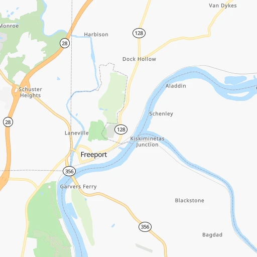
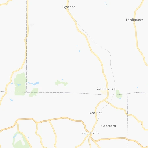
Roadmap (route) to go from Snider Airport to Fort Worth detailed above, you can also see the course layout on the map.
While doing trip Snider (airport) - Fort Worth by car, the calculated route ends at a distance , or more straight.
Distance and duration of the route between Snider (airport) and Fort Worth
Calculation of distance and route from Fort Worth to Snider (airport) :
1,799.52,051.5 km22h34mn
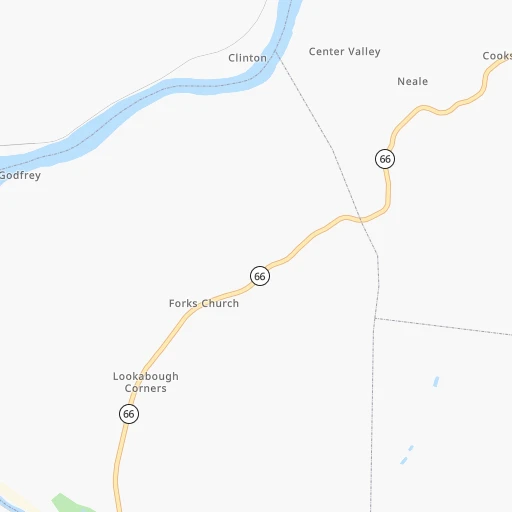
Continue 0h1mn 231 mTurn right onto Railroad Street 0h0mn 191 mKeep left onto Railroad Street 0h0mn 27 mTurn right onto Aladdin Road 0h1mn 663 mContinue onto Schenley Road 0h11mn 5.4 kmTurn right onto PA 66 0h21mn 22.1 kmKeep right onto Coxcomb Hill Road 0h6mn 5.6 kmContinue onto Hulton Road 0h3mn 3.0 kmTurn sharp left onto Freeport Road 0h5mn 5.0 kmKeep left 0h8mn 9.6 kmKeep left and drive toward 40th Street Bridge, Lawrenceville 0h0mn 162 mContinue and take PA 28 toward Pittsburgh 0h1mn 879 mKeep right and drive toward 31st Street Bridge, Strip District 0h0mn 397 mContinue onto Rialto Street 0h0mn 22 mContinue toward PA 28 South 0h2mn 1.7 kmKeep right and take I 579 South, I 279 South toward Veterans Bridge, Monroeville, Fort Pitt Bridge, Airport 0h0mn 55 mKeep right and take I 279 South toward Fort Pitt Bridge, Airport 0h5mn 6.7 kmKeep right and take PA 121 toward Green Tree, Crafton 0h0mn 37 mKeep right and take PA 121 South toward Green Tree 0h4mn 4.1 kmKeep right 0h0mn 161 mTurn slight right onto Greentree Road 0h2mn 2.4 kmTurn left onto Washington Pike 0h4mn 4.3 kmKeep right onto PA 50 0h0mn 56 mKeep left onto Millers Run Road 0h0mn 380 mTurn left 0h18mn 24.3 kmKeep right and take I 70 West toward Wheeling 0h28mn 43.1 kmKeep left onto USS West Virginia Memorial Highway and take I 470 West toward Columbus OH 2h1mn 200.8 kmKeep right and take US 33 East toward Lancaster 0h0mn 476 mContinue onto South James Road 0h1mn 1.5 kmKeep right and take SR 104 toward Refugee Road 0h0mn 240 mKeep right and take SR 104 South toward Refugee Road West 0h7mn 8.7 kmTurn left and take I 71 South toward Cincinnati 2h41mn 163.2 kmKeep left onto Northeast Expressway 0h22mn 33.7 kmKeep right onto I 71 and take I 71 South toward Louisville 1h8mn 115.1 kmKeep left and take I 264 West toward Watterson Expressway 0h13mn 16.8 kmKeep right and take I 65, KY 61 toward Nashville, Indianapolis 0h0mn 294 mKeep right and take KY 61 toward Fair/Expo Center, Gate 6 0h0mn 501 mKeep left toward KY 61 South 0h0mn 43 mTurn left onto Preston Highway 0h2mn 1.5 kmTurn right onto New Grade Lane 0h0mn 292 mTurn left toward I 65 South 1h37mn 61.3 kmKeep right and take KY 61 South toward Elizabethtown, Paducah, Western Kentucky Parkway 0h0mn 329 mKeep right and take US 31W toward Elizabethtown, Paducah, Western Kentucky Parkway West 0h0mn 392 mKeep left and drive toward Paducah, Elizabethtown 2h11mn 219.4 kmKeep right onto I 69 and take I 24 West, I 69 South toward Paducah 0h15mn 26.0 kmKeep left onto I 69 1h50mn 83.6 kmKeep right onto US 51 and drive toward Union City, Memphis 0h0mn 266 mKeep right onto US 51 and drive toward Union City, Memphis 0h15mn 24.9 kmKeep right 0h29mn 44.8 kmKeep right onto US 51 and take US 51 South, US 412 East toward Dyersburg, Jackson 0h1mn 1.6 kmKeep right onto US 51 and take US 51 South toward Dyersburg 0h0mn 229 mKeep left onto US 51 and take US 51 South toward Dyersburg 0h4mn 4.7 kmTurn left onto Troy Avenue 0h1mn 644 mTurn left onto McGaughey Street 0h0mn 54 mTurn right onto North Main Avenue 1h29mn 114.3 kmContinue onto Thomas Street 0h3mn 3.8 kmTurn right onto Chelsea Avenue 0h1mn 562 mTurn left onto North 3rd Street 0h1mn 819 mTurn right onto A. W. Willis Avenue 0h0mn 363 mTurn left onto North Front Street 0h0mn 345 mTurn right 0h9mn 13.1 kmKeep left onto I 40 2h52mn 189.6 kmKeep right and take I 40, AR 440 toward Jacksonville, Texarkana 0h0mn 303 mKeep left and take I 440 West toward Texarkana 6h32mn 572.7 kmKeep right and take I 35W South toward Waco 0h2mn 1.9 kmKeep right onto US 287 Bus and take US 287 Business toward Rosedale Street, Allen Avenue 0h1mn 1.4 kmArrive at destination 0h0mn 0 m
Travel from Snider (airport) (Texas) to a selection of major cities.
Distances from Snider Airport to biggest cities in Pennsylvania
- Mount Lebanon,32,730 inhabitants.49 km
- Bethel Park,32,118 inhabitants.51 km
- Wayne,30,892 inhabitants.370 km
- Radnor,30,878 inhabitants.372 km
- Williamsport,29,201 inhabitants.232 km
- Monroeville,28,176 inhabitants.31 km
- Cranberry Township,28,098 inhabitants.37 km
- Drexel Hill,28,043 inhabitants.380 km
- Plum,27,505 inhabitants.22 km
- Back Mountain,26,973 inhabitants.317 km
- Easton,26,915 inhabitants.375 km
- Pennsport,26,000 inhabitants.392 km
- Lebanon,25,534 inhabitants.278 km
- Whitehall Township,24,896 inhabitants.352 km
- Hazleton,24,825 inhabitants.312 km
- Springfield,23,363 inhabitants.378 km
- Pottstown,22,664 inhabitants.344 km
- New Castle,22,375 inhabitants.67 km
- Allison Park,21,552 inhabitants.28 km
- Chambersburg,20,691 inhabitants.189 km
Other major cities in country :
- Seattle [WA], 684,451 inhabitants. 3,448 km
- Denver [CO], 682,545 inhabitants. 2,147 km
- El Paso [TX], 681,124 inhabitants. 2,592 km
- Detroit [MI], 677,116 inhabitants. 336 km
- Boston [MA], 667,137 inhabitants. 741 km
- Memphis [TN], 655,770 inhabitants. 1,099 km
- New South Memphis [TN], 641,608 inhabitants. 1,104 km
- Portland [OR], 632,309 inhabitants. 3,494 km
- Oklahoma City [OK], 631,346 inhabitants. 1,665 km
- Las Vegas [NV], 623,747 inhabitants. 3,112 km
- Baltimore [MD], 621,849 inhabitants. 303 km
- Washington, D.C. [DC], 601,723 inhabitants. 300 km
- Milwaukee [WI], 600,155 inhabitants. 731 km
- South Boston [MA], 571,281 inhabitants. 741 km
- Albuquerque [NM], 559,121 inhabitants. 2,441 km
- Tucson [AZ], 531,641 inhabitants. 2,935 km
- Nashville [TN], 530,852 inhabitants. 798 km
- Fresno [CA], 520,052 inhabitants. 3,481 km
- Sacramento [CA], 490,712 inhabitants. 3,560 km
- Kansas City [MO], 475,378 inhabitants. 1,284 km
Route from Fort Worth to major cities (United States).
- Distance Fort Worth New York City2,254 km
- Distance Fort Worth Los Angeles1,947 km
- Distance Fort Worth Chicago1,327 km
- Distance Fort Worth Brooklyn2,256 km
- Distance Fort Worth Queens2,266 km
- Distance Fort Worth Philadelphia2,136 km
- Distance Fort Worth Phoenix1,377 km
- Distance Fort Worth Manhattan2,259 km
- Distance Fort Worth San Diego1,856 km
- Distance Fort Worth The Bronx2,269 km
- Distance Fort Worth San Jose2,291 km
- Distance Fort Worth Jacksonville1,509 km
- Distance Fort Worth San Francisco2,342 km
- Distance Fort Worth Columbus1,513 km
- Distance Fort Worth Indianapolis1,271 km
- Distance Fort Worth Charlotte1,545 km
- Distance Fort Worth Seattle2,676 km
- Distance Fort Worth Denver1,040 km
- Distance Fort Worth Detroit1,649 km
- Distance Fort Worth Boston2,540 km
Nearest cities to Snider (airport) :
- Washington, D.C., 601,723 inhabitants. 300 km
- Cleveland, 388,072 inhabitants. 193 km
- Pittsburgh, 304,391 inhabitants. 39 km
- Buffalo, 258,071 inhabitants. 254 km
- Rochester, 209,802 inhabitants. 323 km
- Arlington, 207,627 inhabitants. 297 km
- Akron, 197,542 inhabitants. 162 km
- Alexandria, 153,511 inhabitants. 307 km
- Amherst, 122,366 inhabitants. 265 km
- Columbia, 99,615 inhabitants. 290 km
- Erie, 99,475 inhabitants. 165 km
- Germantown, 86,395 inhabitants. 265 km
- Parma, 79,937 inhabitants. 190 km
- Cheektowaga, 75,178 inhabitants. 258 km
- Canton, 71,885 inhabitants. 145 km
- Silver Spring, 71,452 inhabitants. 294 km
- Centreville, 71,135 inhabitants. 281 km
- Frederick, 69,479 inhabitants. 239 km
- Waldorf, 67,752 inhabitants. 327 km
- Gaithersburg, 67,456 inhabitants. 271 km
- Rockville, 66,980 inhabitants. 279 km
- Dale City, 65,969 inhabitants. 304 km
- Ellicott City, 65,834 inhabitants. 291 km
- Youngstown, 64,628 inhabitants. 95 km
- Lorain, 63,647 inhabitants. 228 km
- Bethesda, 60,858 inhabitants. 290 km
- Reston, 58,404 inhabitants. 276 km
- Bowie, 58,025 inhabitants. 317 km
- Elyria, 53,775 inhabitants. 219 km
- Harrisonburg, 52,538 inhabitants. 258 km
- Irondequoit, 51,692 inhabitants. 330 km
- Leesburg, 51,209 inhabitants. 250 km
- Lakewood, 50,656 inhabitants. 200 km
- Charleston, 49,736 inhabitants. 310 km
- Cuyahoga Falls, 49,146 inhabitants. 161 km
- Harrisburg, 49,081 inhabitants. 240 km
- Niagara Falls, 48,916 inhabitants. 273 km
- Aspen Hill, 48,759 inhabitants. 285 km
- Huntington, 48,638 inhabitants. 347 km
- Wheaton, 48,284 inhabitants. 289 km
- McLean, 48,115 inhabitants. 288 km
- Newark, 47,986 inhabitants. 242 km
- Euclid, 47,676 inhabitants. 186 km
- Mentor, 46,901 inhabitants. 178 km
- Mansfield, 46,830 inhabitants. 241 km
- Charlottesville, 46,597 inhabitants. 313 km
- Altoona, 45,344 inhabitants. 109 km
- Potomac, 44,965 inhabitants. 280 km
- Cleveland Heights, 44,962 inhabitants. 184 km
- West Seneca, 44,711 inhabitants. 252 km
Location Snider (airport) (Pennsylvania) :
| Country flag |  |
| Location | Snider (airport) |
| State | Pennsylvania |
| County | Armstrong County |
| Country | United States |
| Country code / ISO 2 | US |
| Latitude | 40.6834000 |
| Longitude | -79.6664400 |
| Altitude | 227 meters |
| Time zone | America/New_York |
Location Fort Worth (Texas) :
| Country flag | |
| Location | Fort Worth |
| State | Texas |
| County | Tarrant County |
| Country | United States |
| Country code / ISO 2 | US |
| Latitude | 32.7254100 |
| Longitude | -97.3208500 |
| Altitude | 199 meters |
| Time zone | America/Chicago |


