
How to get from Ginny 'B' (airport) (Tennessee) to Gadsden (Alabama)
Calculate route from Ginny 'B' (airport) (Tennessee, United States) to Gadsden (Alabama, United States).
The flight distance (as the crow flies) between Ginny 'B' (airport) and Gadsden is 238.4 km.
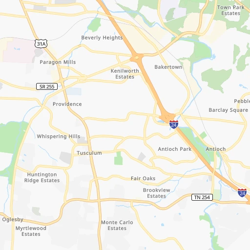
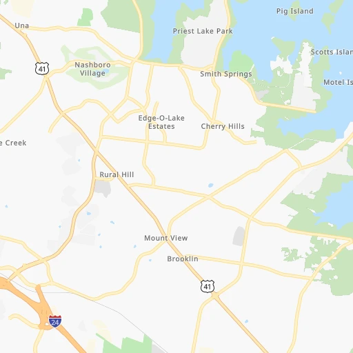
Roadmap (route) to go from Ginny 'B' Airport to Gadsden detailed above, you can also see the course layout on the map.
While doing trip Ginny 'B' (airport) - Gadsden by car, the calculated route ends at a distance , or more straight.
Distance and duration of the route between Ginny 'B' (airport) and Gadsden
Calculation of distance and route from Gadsden to Ginny 'B' (airport) :
238.4307.0 km3h11mn
Continue 0h1mn 269 mTurn left 0h0mn 90 mTurn left 0h0mn 104 mTurn right onto Murfreesboro Pike 0h2mn 2.6 kmTurn right onto Bell Road 0h3mn 2.9 kmTurn sharp left onto Mount View Road 0h1mn 574 mTurn right onto Mount View Parkway 0h0mn 366 mTurn left toward I 24 0h0mn 326 mKeep left and take I 24 East toward Murfreesboro 0h0mn 340 mKeep left and take I 24 East toward Murfreesboro 2h45mn 172.8 kmKeep right and take I 59 South toward Birmingham 1h9mn 117.8 kmKeep right and take AL 211 toward Noccalula Falls Park 0h0mn 343 mTurn left onto Noccalula Parkway 0h7mn 6.9 kmKeep left onto West Meighan Boulevard 0h1mn 1.2 kmKeep right onto North Henry Street 0h0mn 57 mKeep right onto North 7th Street 0h0mn 218 mTurn left onto Broad Street 0h0mn 176 mTurn right onto South 6th Street 0h0mn 5 mArrive at destination 0h0mn 0 m
Travel from Ginny 'B' (airport) (Alabama) to a selection of major cities.
Distances from Ginny 'B' Airport to biggest cities in Tennessee
- Spring Hill,36,055 inhabitants.45 km
- La Vergne,34,794 inhabitants.11 km
- Gallatin,34,334 inhabitants.38 km
- Cookeville,32,113 inhabitants.104 km
- Mount Juliet,31,540 inhabitants.17 km
- Brentwood Estates,31,279 inhabitants.14 km
- Lebanon,30,262 inhabitants.35 km
- Morristown,29,478 inhabitants.302 km
- Oak Ridge,29,302 inhabitants.215 km
- Maryville,28,464 inhabitants.245 km
- Bristol,26,666 inhabitants.404 km
- Farragut,21,919 inhabitants.226 km
- Shelbyville,21,317 inhabitants.70 km
- East Ridge,20,979 inhabitants.175 km
Other major cities in country :
- Charlotte [NC], 827,097 inhabitants. 534 km
- Seattle [WA], 684,451 inhabitants. 3,188 km
- Denver [CO], 682,545 inhabitants. 1,657 km
- El Paso [TX], 681,124 inhabitants. 1,891 km
- Detroit [MI], 677,116 inhabitants. 761 km
- Boston [MA], 667,137 inhabitants. 1,512 km
- Portland [OR], 632,309 inhabitants. 3,180 km
- Oklahoma City [OK], 631,346 inhabitants. 983 km
- Las Vegas [NV], 623,747 inhabitants. 2,551 km
- Baltimore [MD], 621,849 inhabitants. 953 km
- Washington, D.C. [DC], 601,723 inhabitants. 904 km
- Milwaukee [WI], 600,155 inhabitants. 781 km
- South Boston [MA], 571,281 inhabitants. 1,511 km
- Albuquerque [NM], 559,121 inhabitants. 1,810 km
- Tucson [AZ], 531,641 inhabitants. 2,271 km
- Fresno [CA], 520,052 inhabitants. 2,953 km
- Sacramento [CA], 490,712 inhabitants. 3,078 km
- Kansas City [MO], 475,378 inhabitants. 775 km
- Long Beach [CA], 474,140 inhabitants. 2,877 km
- Mesa [AZ], 471,825 inhabitants. 2,314 km
Route from Gadsden to major cities (United States).
- Distance Gadsden New York City1,296 km
- Distance Gadsden Los Angeles2,961 km
- Distance Gadsden Chicago884 km
- Distance Gadsden Brooklyn1,296 km
- Distance Gadsden Houston1,002 km
- Distance Gadsden Queens1,306 km
- Distance Gadsden Philadelphia1,168 km
- Distance Gadsden Phoenix2,408 km
- Distance Gadsden Manhattan1,302 km
- Distance Gadsden San Antonio1,287 km
- Distance Gadsden San Diego2,889 km
- Distance Gadsden The Bronx1,313 km
- Distance Gadsden Dallas1,013 km
- Distance Gadsden San Jose3,247 km
- Distance Gadsden Austin1,181 km
- Distance Gadsden Jacksonville580 km
- Distance Gadsden San Francisco3,289 km
- Distance Gadsden Columbus714 km
- Distance Gadsden Fort Worth1,061 km
- Distance Gadsden Indianapolis641 km
Nearest cities to Ginny 'B' (airport) :
- Nashville, 530,852 inhabitants. 14 km
- Atlanta, 463,878 inhabitants. 333 km
- Lexington-Fayette, 314,488 inhabitants. 292 km
- Louisville, 243,639 inhabitants. 253 km
- Lexington, 225,366 inhabitants. 286 km
- Birmingham, 212,461 inhabitants. 287 km
- Huntsville, 190,582 inhabitants. 152 km
- Knoxville, 185,291 inhabitants. 247 km
- Chattanooga, 176,588 inhabitants. 169 km
- East Chattanooga, 154,024 inhabitants. 171 km
- Clarksville, 149,176 inhabitants. 80 km
- Murfreesboro, 126,118 inhabitants. 36 km
- Evansville, 119,943 inhabitants. 224 km
- Sandy Springs, 105,330 inhabitants. 318 km
- Tuscaloosa, 98,332 inhabitants. 332 km
- Roswell, 94,501 inhabitants. 311 km
- Hoover, 84,848 inhabitants. 300 km
- Johns Creek, 83,335 inhabitants. 321 km
- Franklin, 72,639 inhabitants. 27 km
- Jackson, 66,975 inhabitants. 202 km
- Alpharetta, 63,693 inhabitants. 311 km
- Bowling Green, 63,616 inhabitants. 102 km
- Marietta, 59,067 inhabitants. 306 km
- Owensboro, 59,042 inhabitants. 192 km
- Smyrna, 56,146 inhabitants. 314 km
- Hendersonville, 56,018 inhabitants. 24 km
- Decatur, 55,437 inhabitants. 168 km
- Brookhaven, 51,910 inhabitants. 326 km
- Stonecrest, 50,000 inhabitants. 351 km
- Dunwoody, 48,733 inhabitants. 319 km
- Madison, 46,962 inhabitants. 155 km
- Jeffersonville, 46,960 inhabitants. 256 km
- Smyrna, 46,607 inhabitants. 17 km
- Cleveland, 43,898 inhabitants. 192 km
- Brentwood, 41,763 inhabitants. 13 km
- Covington, 40,997 inhabitants. 383 km
- Peachtree Corners, 40,978 inhabitants. 324 km
- North Atlanta, 40,456 inhabitants. 326 km
- Florence, 40,026 inhabitants. 171 km
- Cape Girardeau, 39,462 inhabitants. 289 km
- Gainesville, 38,712 inhabitants. 326 km
- Milton, 37,547 inhabitants. 306 km
- Newnan, 37,291 inhabitants. 346 km
- Mableton, 37,115 inhabitants. 316 km
- Columbia, 36,800 inhabitants. 63 km
- New Albany, 36,732 inhabitants. 255 km
- Rome, 36,323 inhabitants. 245 km
- Gadsden, 36,084 inhabitants. 239 km
- Spring Hill, 36,055 inhabitants. 45 km
- East Florence, 35,733 inhabitants. 169 km
Location Ginny 'B' (airport) (Tennessee) :
| Country flag |  |
| Location | Ginny 'B' (airport) |
| State | Tennessee |
| County | Davidson County |
| Country | United States |
| Country code / ISO 2 | US |
| Latitude | 36.0931100 |
| Longitude | -86.6547200 |
| Altitude | 203 meters |
| Time zone | America/Chicago |
Location Gadsden (Alabama) :
| Country flag | |
| Location | Gadsden |
| State | Alabama |
| County | Etowah County |
| Country | United States |
| Country code / ISO 2 | US |
| Latitude | 34.0143400 |
| Longitude | -86.0063900 |
| Altitude | 167 meters |
| Time zone | America/Chicago |


