

How to get from Jeremoabo (Bahia) to Santo Antônio de Jesus (Bahia)
Calculate route from Jeremoabo (Bahia, Brazil) to Santo Antônio de Jesus (Bahia, Brazil).
The flight distance (as the crow flies) between Jeremoabo and Santo Antônio de Jesus is 332.6 km.
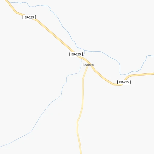
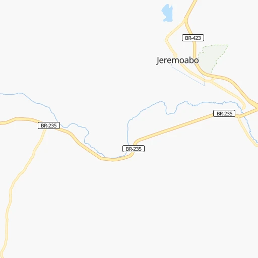
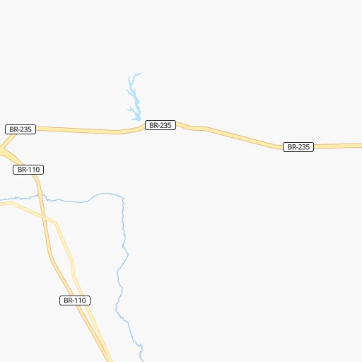
Roadmap (route) to go from Jeremoabo to Santo Antônio de Jesus detailed above, you can also see the course layout on the map.
While doing trip Jeremoabo - Santo Antônio de Jesus by car, the calculated route ends at a distance , or more straight.
Distance and duration of the route between Jeremoabo and Santo Antônio de Jesus
Calculation of distance and route from Santo Antônio de Jesus to Jeremoabo :
332.6398.0 km6h49mn
Continue onto BR-235 0h18mn 20.6 kmContinue onto BR-110 1h17mn 91.6 kmAt roundabout, take exit 1 onto BR-410 1h30mn 35.8 kmAt roundabout, take exit 2 onto Rodovia Santos Dumont 2h35mn 110.5 kmTurn right 0h26mn 30.5 kmKeep right 0h5mn 4.6 kmAt roundabout, take exit 2 onto Avenida José Falcão 0h2mn 2.2 kmTurn left onto Avenida Senhor dos Passos 0h2mn 1.8 kmTurn right onto Rua Esther Freitas 0h0mn 38 mTurn left onto Rua Doutor Araújo Pinho 0h0mn 142 mTurn right onto Rua Bruno Pereira do Nascimento 0h0mn 29 mTurn left onto Rua Papa João XXIII 0h17mn 16.6 kmTurn left 0h3mn 3.0 kmContinue onto Avenida Coronel Adriano Pedreira 0h1mn 811 mKeep left 0h0mn 112 mTurn left onto Rua Sete Portas 0h1mn 348 mContinue 0h4mn 2.0 kmKeep left 0h2mn 996 mTurn slight right onto Rodovia Governador Mário Covas 1h3mn 72.9 kmKeep left onto Acesso à BA-028 0h1mn 982 mTurn right onto Rua Welington Figueiredo 0h1mn 785 mTurn right onto Avenida Barros e Almeida 0h1mn 493 mTurn left onto Rua do Expedicionário 0h0mn 7 mKeep right onto Rua do Expedicionário 0h1mn 320 mTurn right onto Avenida Luiz Viana 0h0mn 127 mMake a U-turn onto Avenida Luiz Viana 0h0mn 269 mTurn right onto Praça Madre Maria do Rosário 0h0mn 33 mTurn slight right onto Rua Sete de Setembro 0h0mn 40 mTurn left onto Travessa Castro Alves 0h0mn 162 mTurn right onto Rua Castro Alves 0h0mn 136 mTurn slight left onto Rua Saldanha Marinho 0h0mn 118 mTurn left onto Rua Celestino Pimenta 0h0mn 19 mArrive at destination 0h0mn 0 m
Travel from Jeremoabo (Bahia) to a selection of major cities.
Distances from Jeremoabo to biggest cities in Bahia
- Serrinha,49,078 inhabitants.186 km
- Senhor do Bonfim,48,471 inhabitants.192 km
- Cruz das Almas,47,844 inhabitants.297 km
- Jacobina,47,637 inhabitants.254 km
- Itamaraju,47,628 inhabitants.784 km
- Itaberaba,47,301 inhabitants.338 km
- Santo Amaro,46,748 inhabitants.276 km
- Brumado,41,989 inhabitants.576 km
- Jaguaquara,41,498 inhabitants.418 km
- Bom Jesus da Lapa,40,691 inhabitants.644 km
- Catu,39,932 inhabitants.254 km
- Ipiau,38,762 inhabitants.472 km
- Xique Xique,35,433 inhabitants.472 km
- Pocoes,35,254 inhabitants.537 km
- Conceicao do Coite,35,171 inhabitants.188 km
- Coaraci,32,344 inhabitants.521 km
- Tucano,31,203 inhabitants.104 km
- Sao Sebastiao do Passe,31,049 inhabitants.271 km
- Vera Cruz,30,556 inhabitants.398 km
- Euclides da Cunha,29,738 inhabitants.76 km
Other major cities in country :
- Campo Grande [11], 729,151 inhabitants. 2,082 km
- Jaboatao [30], 702,621 inhabitants. 437 km
- Osasco [27], 677,856 inhabitants. 1,739 km
- Santo Andre [27], 662,373 inhabitants. 1,738 km
- Joao Pessoa [17], 650,883 inhabitants. 517 km
- Jaboatao dos Guararapes [30], 630,008 inhabitants. 439 km
- Contagem [15], 627,123 inhabitants. 1,250 km
- Ribeirao Preto [27], 619,746 inhabitants. 1,589 km
- Sao Jose dos Campos [27], 613,764 inhabitants. 1,658 km
- Uberlandia [15], 563,536 inhabitants. 1,443 km
- Sorocaba [27], 558,862 inhabitants. 1,773 km
- Cuiaba [14], 521,934 inhabitants. 2,007 km
- Aparecida de Goiania [29], 510,770 inhabitants. 1,386 km
- Aracaju [28], 490,175 inhabitants. 180 km
- Londrina [18], 471,832 inhabitants. 1,997 km
- Juiz de Fora [15], 470,193 inhabitants. 1,401 km
- Belford Roxo [21], 466,096 inhabitants. 1,507 km
- Joinville [26], 461,304 inhabitants. 2,111 km
- Niteroi [21], 456,456 inhabitants. 1,508 km
- Sao Joao de Meriti [21], 454,849 inhabitants. 1,510 km
Route from Santo Antônio de Jesus to major cities (Brazil).
- Distance Santo Antônio de Jesus Sao Paulo1,411 km
- Distance Santo Antônio de Jesus Rio de Janeiro1,181 km
- Distance Santo Antônio de Jesus Fortaleza1,033 km
- Distance Santo Antônio de Jesus Belo Horizonte921 km
- Distance Santo Antônio de Jesus Brasilia986 km
- Distance Santo Antônio de Jesus Curitiba1,739 km
- Distance Santo Antônio de Jesus Manaus2,536 km
- Distance Santo Antônio de Jesus Recife727 km
- Distance Santo Antônio de Jesus Belem1,637 km
- Distance Santo Antônio de Jesus Porto Alegre2,264 km
- Distance Santo Antônio de Jesus Goiania1,152 km
- Distance Santo Antônio de Jesus Guarulhos1,398 km
- Distance Santo Antônio de Jesus Campinas1,380 km
- Distance Santo Antônio de Jesus Nova Iguacu1,177 km
- Distance Santo Antônio de Jesus Maceio532 km
- Distance Santo Antônio de Jesus Sao Luis1,288 km
- Distance Santo Antônio de Jesus Duque de Caxias1,174 km
- Distance Santo Antônio de Jesus Natal914 km
- Distance Santo Antônio de Jesus Teresina960 km
- Distance Santo Antônio de Jesus Sao Bernardo do Campo1,421 km
Nearest cities to Jeremoabo :
- Salvador, 2,711,840 inhabitants. 322 km
- Maceio, 954,991 inhabitants. 305 km
- Aracaju, 490,175 inhabitants. 180 km
- Feira de Santana, 481,911 inhabitants. 250 km
- Campina Grande, 348,936 inhabitants. 427 km
- Caruaru, 235,371 inhabitants. 340 km
- Juazeiro do Norte, 225,230 inhabitants. 332 km
- Petrolina, 194,650 inhabitants. 234 km
- Camacari, 188,758 inhabitants. 292 km
- Arapiraca, 166,562 inhabitants. 203 km
- Nossa Senhora do Socorro, 163,993 inhabitants. 172 km
- Lauro de Freitas, 141,280 inhabitants. 314 km
- Alagoinhas, 122,688 inhabitants. 229 km
- Simoes Filho, 116,662 inhabitants. 302 km
- Garanhuns, 110,085 inhabitants. 255 km
- Crato, 88,786 inhabitants. 332 km
- Paulo Afonso, 85,350 inhabitants. 80 km
- Santa Cruz do Capibaribe, 76,450 inhabitants. 344 km
- Santo Antonio de Jesus, 73,957 inhabitants. 333 km
- Sao Cristovao, 71,539 inhabitants. 174 km
- Itabaiana, 63,888 inhabitants. 134 km
- Rio Largo, 63,387 inhabitants. 296 km
- Gravata, 61,249 inhabitants. 382 km
- Picos, 57,495 inhabitants. 468 km
- Arcoverde, 57,163 inhabitants. 242 km
- Estancia, 55,654 inhabitants. 175 km
- Bezerros, 51,436 inhabitants. 359 km
- Serra Talhada, 51,203 inhabitants. 233 km
- Marechal Deodoro, 50,571 inhabitants. 286 km
- Belo Jardim, 49,922 inhabitants. 298 km
- Serrinha, 49,078 inhabitants. 186 km
- Senhor do Bonfim, 48,471 inhabitants. 192 km
- Cruz das Almas, 47,844 inhabitants. 297 km
- Jacobina, 47,637 inhabitants. 254 km
- Itaberaba, 47,301 inhabitants. 338 km
- Santo Amaro, 46,748 inhabitants. 276 km
- Lagarto, 45,445 inhabitants. 131 km
- Salgueiro, 42,152 inhabitants. 234 km
- Penedo, 42,097 inhabitants. 209 km
- Pesqueira, 41,896 inhabitants. 274 km
- Palmares, 41,679 inhabitants. 353 km
- Uniao dos Palmares, 41,178 inhabitants. 287 km
- Sao Miguel dos Campos, 40,890 inhabitants. 264 km
- Catu, 39,932 inhabitants. 254 km
- Araripina, 38,569 inhabitants. 356 km
- Delmiro Gouveia, 35,259 inhabitants. 93 km
- Conceicao do Coite, 35,171 inhabitants. 188 km
- Surubim, 34,580 inhabitants. 390 km
- Barbalha, 33,943 inhabitants. 321 km
- Coruripe, 31,427 inhabitants. 253 km
Location Jeremoabo (Bahia) :
| Country flag |  |
| Location | Jeremoabo |
| State | Bahia |
| County | Jeremoabo |
| Country | Brazil |
| Country code / ISO 2 | BR |
| Latitude | -10.0750000 |
| Longitude | -38.4808300 |
| Altitude | 0 meters |
| Time zone | America/Bahia |
Location Santo Antônio de Jesus (Bahia) :
| Country flag | |
| Location | Santo Antônio de Jesus |
| State | Bahia |
| County | Santo Antônio de Jesus |
| Country | Brazil |
| Country code / ISO 2 | BR |
| Latitude | -12.9688900 |
| Longitude | -39.2613900 |
| Altitude | 0 meters |
| Time zone | America/Bahia |

