


How to get from Sumbe (Kwanza Sul) to Benguela (Benguela)
Calculate route from Sumbe (Kwanza Sul, Angola) to Benguela (Benguela, Angola).
The flight distance (as the crow flies) between Sumbe and Benguela is 159.5 km.
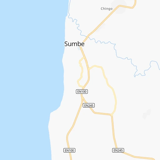
Roadmap (route) to go from Sumbe to Benguela detailed above, you can also see the course layout on the map.
While doing trip Sumbe - Benguela by car, the calculated route ends at a distance , or more straight.
Distance and duration of the route between Sumbe and Benguela
Calculation of distance and route from Benguela to Sumbe :
159.5208.9 km3h11mn
Continue onto Avenida dos Aliados 2h15mn 148.3 kmContinue onto Canjala-Lobito 0h26mn 28.0 kmAt roundabout, take exit 2 onto EN100, EN250 0h0mn 365 mTurn sharp left 0h5mn 4.0 kmTurn left onto Avenida Paulo Dias de Novais 0h1mn 1.4 kmAt roundabout, take exit 2 onto Catumbela-Lobito 0h22mn 25.2 kmAt roundabout, take exit 1 onto EN 100 0h1mn 1.5 kmTurn right 0h0mn 117 mTurn left onto Rua Comendador Inácio da Fonceca 0h0mn 107 mArrive at destination 0h0mn 0 m
Travel from Sumbe (Benguela) to a selection of major cities.
Distances from Sumbe to biggest cities in Kwanza Sul
Other major cities in country :
Route from Benguela to major cities (Angola).
- Distance Benguela Luanda417 km
- Distance Benguela N'dalatando400 km
- Distance Benguela Huambo254 km
- Distance Benguela Cuito384 km
- Distance Benguela Lubango261 km
- Distance Benguela Malanje466 km
- Distance Benguela Namibe322 km
- Distance Benguela Soio726 km
- Distance Benguela Cabinda793 km
- Distance Benguela Uige582 km
Nearest cities to Sumbe :
- Luanda, 2,776,168 inhabitants. 272 km
- N'dalatando, 383,100 inhabitants. 243 km
- Huambo, 226,145 inhabitants. 270 km
- Lobito, 207,932 inhabitants. 133 km
- Benguela, 151,226 inhabitants. 160 km
- Malanje, 87,046 inhabitants. 330 km
- Sumbe, 33,277 inhabitants. 0 km
- Caluquembe, 30,300 inhabitants. 301 km
- Caxito, 28,224 inhabitants. 293 km
- Longonjo, 24,346 inhabitants. 244 km
- Caala, 21,205 inhabitants. 262 km
- Catumbela, 16,977 inhabitants. 140 km
- Uacu Cungo, 10,970 inhabitants. 140 km
- Caconda, 10,549 inhabitants. 311 km
- Quibala, 8,915 inhabitants. 135 km
- Chela, 5,811 inhabitants. 212 km
Location Sumbe (Kwanza Sul) :
| Country flag |  |
| Location | Sumbe |
| State | Kwanza Sul |
| County | |
| Country | Angola |
| Country code / ISO 2 | AO |
| Latitude | -11.2060500 |
| Longitude | 13.8437100 |
| Altitude | 0 meters |
| Time zone | Africa/Luanda |
Location Benguela (Benguela) :
| Country flag | |
| Location | Benguela |
| State | Benguela |
| County | |
| Country | Angola |
| Country code / ISO 2 | AO |
| Latitude | -12.5762600 |
| Longitude | 13.4054700 |
| Altitude | 0 meters |
| Time zone | Africa/Luanda |
